Skaryszew geodata
Skaryszew (Mazovia) is a seat of a third-order administrative division; located in Poland in Europe/Warsaw (GMT+2) time zone. With population of 4,135 people, there are 789 cities with bigger population in this country. Compared to other cities in Poland, 53.4% of cities are located further ↓South; 76.4% of cities are located further ←West and 51.5% of cities have lower elevation than Skaryszew. Note1


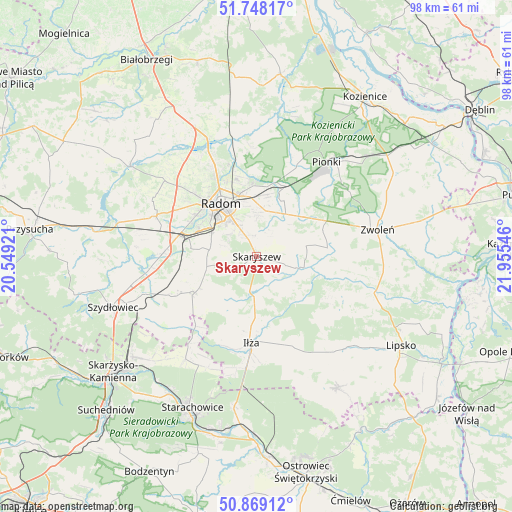
Skaryszew GPS coordinates[2]
51° 18' 38.7" North, 21° 15' 8.388" East
| Map corner | latitude | longitude |
|---|---|---|
| Upper-left | 51.74817°, | 20.54921° |
| Center: | 51.31075°, | 21.25233° |
| Lower-right: | 50.86912°, | 21.95546° |
| Map W x H: | 97.7×97.7 km | = 60.7×60.7mi |
| max Lat: | 54.83135° ⇑46.6% North |
| Skaryszew: | 51.31075° |
| min Lat: | ⇓53.4% South 49.21328° |
| min Long | Skaryszew | max Long |
| 14.20249° | 21.25233° | 24.03723° |
| W 76.4%⇐ | ⇒23.6% E |
Elevation
Elevation of Skaryszew is 176 m = 577 ft, and this is 15.4 m = 51 ft below average elevation for this country.
| Max E: |
974 m = 3196 ft | 48.5% |
| Avg. | 191.4 m = 628 ft | |
| Skaryszew | 176 m = 577 ft | |
Min E: |
-3 m = -10 ft | 51.5% |
See also: Poland elevation on elevation.city.
Geographical zone
Skaryszew is located in North temperate zone (between Tropic of Cancer and the Arctic Circle). Distance of this North polar circle is 1696 km =1053.8 mi to North.| Distance of | km | miles | from Skaryszew |
|---|---|---|---|
| North Pole | 4301.8 | 2673 | to North |
| Arctic Circle | 1696 | 1053.8 | to North |
| Tropic Cancer | 3099.3 | 1925.8 | to South |
| Equator | 5705.2 | 3545 | to South |


Nearby cities:
15 places around Skaryszew: (largest is in red/bold)
• Gózd
11.6 km =7.2 mi,  49°
49°
• Iłża
16.4 km =10.2 mi,  183°
183°
• Jedlnia-Letnisko
14.5 km =9 mi,  23°
23°
• Kazanów
15.4 km =9.6 mi,  104°
104°
• Kowala
12.8 km =8 mi,  277°
277°
• Ludwinów
11.7 km =7.3 mi,  290°
290°
• Maków
3.9 km =2.4 mi,  0°
0°
• Mazowszany
8.7 km =5.4 mi, 291°
• Orońsko
18.2 km =11.3 mi,  270°
270°
• Pakosław
14.3 km =8.9 mi,  201°
201°
• Radom
12.5 km =7.8 mi,  324°
324°
• Rzeczków
14.2 km =8.8 mi,  249°
249°
• Tczów
13.6 km =8.5 mi,  82°
82°
• Trablice
9.8 km =6.1 mi,  298°
298°
• Wierzbica
13.6 km =8.5 mi,  239°
239°
Sources, notices
• [Note1] Compared only with cities in Poland existing in our database
• [Src1] Map data: © OpenStreetMap contributors (CC-BY-SA)
• [Src2] Other city data from geonames.org with taken over terms of usage.
• [Src3] Geographical zone / Annual Mean Temperature by Robert A. Rohde @ Wikipedia
