Iłża geodata
Iłża (Mazovia) is a seat of a third-order administrative division; located in Poland in Europe/Warsaw (GMT+2) time zone. With population of 5,121 people, there are 676 cities with bigger population in this country. Compared to other cities in Poland, 50.1% of cities are located further ↑North; 76.2% of cities are located further ←West and 53.8% of cities have lower elevation than Iłża. Note1


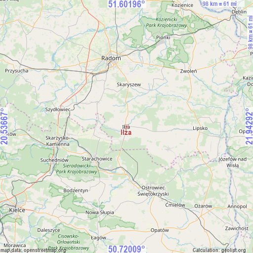
Iłża GPS coordinates[2]
51° 9' 47.268" North, 21° 14' 23.244" East
| Map corner | latitude | longitude |
|---|---|---|
| Upper-left | 51.60196°, | 20.53667° |
| Center: | 51.16313°, | 21.23979° |
| Lower-right: | 50.72009°, | 21.94292° |
| Map W x H: | 98.1×98.1 km | = 61×61mi |
| max Lat: | 54.83135° ⇑50.1% North |
| Iłża: | 51.16313° |
| min Lat: | ⇓49.9% South 49.21328° |
| min Long | Iłża | max Long |
| 14.20249° | 21.23979° | 24.03723° |
| W 76.2%⇐ | ⇒23.8% E |
Elevation
Elevation of Iłża is 182 m = 597 ft, and this is 9.4 m = 31 ft below average elevation for this country.
| Max E: |
974 m = 3196 ft | 46.2% |
| Avg. | 191.4 m = 628 ft | |
| Iłża | 182 m = 597 ft | |
Min E: |
-3 m = -10 ft | 53.8% |
See also: Poland elevation on elevation.city.
Geographical zone
Iłża is located in North temperate zone (between Tropic of Cancer and the Arctic Circle). Distance of this North polar circle is 1712.4 km =1064 mi to North.| Distance of | km | miles | from Iłża |
|---|---|---|---|
| North Pole | 4318.3 | 2683.3 | to North |
| Arctic Circle | 1712.4 | 1064 | to North |
| Tropic Cancer | 3082.9 | 1915.6 | to South |
| Equator | 5688.8 | 3534.9 | to South |


Nearby cities:
15 places around Iłża: (largest is in red/bold)
• Adamów
17.2 km =10.7 mi,  201°
201°
• Brody
15.4 km =9.6 mi,  184°
184°
• Mirzec
13.1 km =8.1 mi,  256°
256°
• Mirów
14.9 km =9.3 mi,  284°
284°
• Mirów Stary
13.9 km =8.6 mi, 280°
• Pakosław
5.5 km =3.4 mi,  305°
305°
• Prędocin
6.3 km =3.9 mi,  105°
105°
• Rogów
16.6 km =10.3 mi, 283°
• Rzeczków
17 km =10.6 mi, 312°
• Rzeczniów
14.5 km =9 mi, 105°
• Sienno
18.9 km =11.7 mi,  116°
116°
• Skaryszew
16.4 km =10.2 mi,  3°
3°
• Starachowice
18.3 km =11.4 mi,  220°
220°
• Wierzbica
14.6 km =9.1 mi, 311°
• Wąchock
18.7 km =11.6 mi,  237°
237°
Sources, notices
• [Note1] Compared only with cities in Poland existing in our database
• [Src1] Map data: © OpenStreetMap contributors (CC-BY-SA)
• [Src2] Other city data from geonames.org with taken over terms of usage.
• [Src3] Geographical zone / Annual Mean Temperature by Robert A. Rohde @ Wikipedia
