Skrzyszów geodata
Skrzyszów (Lesser Poland) is a seat of a third-order administrative division; located in Poland in Europe/Warsaw (GMT+2) time zone. With population of 3,656 people, there are 882 cities with bigger population in this country. Compared to other cities in Poland, 82.9% of cities are located further ↑North; 73.8% of cities are located further ←West and 66.7% of cities have lower elevation than Skrzyszów. Note1


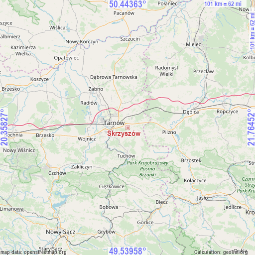
Skrzyszów GPS coordinates[2]
49° 59' 37.428" North, 21° 3' 41.004" East
| Map corner | latitude | longitude |
|---|---|---|
| Upper-left | 50.44363°, | 20.35827° |
| Center: | 49.99373°, | 21.06139° |
| Lower-right: | 49.53958°, | 21.76452° |
| Map W x H: | 100.5×100.5 km | = 62.4×62.4mi |
| max Lat: | 54.83135° ⇑82.9% North |
| Skrzyszów: | 49.99373° |
| min Lat: | ⇓17.1% South 49.21328° |
| min Long | Skrzyszów | max Long |
| 14.20249° | 21.06139° | 24.03723° |
| W 73.8%⇐ | ⇒26.2% E |
Elevation
Elevation of Skrzyszów is 219 m = 719 ft, and this is 27.6 m = 91 ft above average elevation for this country.
| Max E: |
974 m = 3196 ft | 33.3% |
| Skrzyszów | 219 m 719 ft | |
| Avg. | 191.4 m = 628 ft | |
Min E: |
-3 m = -10 ft | 66.7% |
See also: Poland elevation on elevation.city.
Geographical zone
Skrzyszów is located in North temperate zone (between Tropic of Cancer and the Arctic Circle). Distance of this North polar circle is 1842.4 km =1144.8 mi to North.| Distance of | km | miles | from Skrzyszów |
|---|---|---|---|
| North Pole | 4448.3 | 2764 | to North |
| Arctic Circle | 1842.4 | 1144.8 | to North |
| Tropic Cancer | 2952.9 | 1834.8 | to South |
| Equator | 5558.8 | 3454.1 | to South |


Nearby cities:
15 places around Skrzyszów: (largest is in red/bold)
• Błonie
12.2 km =7.6 mi,  247°
247°
• Jodłówka-Wałki
8.1 km =5 mi,  39°
39°
• Karwodrza
7.5 km =4.7 mi,  173°
173°
• Koszyce
8.9 km =5.5 mi, 254°
• Koszyce Wielkie
8.4 km =5.2 mi,  260°
260°
• Lisia Góra
9.7 km =6 mi,  352°
352°
• Pleśna
11.2 km =7 mi,  227°
227°
• Pogórska Wola
7.4 km =4.6 mi,  68°
68°
• Rychwałd
13.1 km =8.1 mi,  222°
222°
• Szynwałd
5.3 km =3.3 mi,  123°
123°
• Tarnowiec
5.5 km =3.4 mi, 255°
• Tarnów
5.8 km =3.6 mi,  292°
292°
• Tuchów
11 km =6.8 mi,  182°
182°
• Łukowa
12.6 km =7.8 mi,  330°
330°
• Łęki Górne
8.4 km =5.2 mi,  105°
105°
Sources, notices
• [Note1] Compared only with cities in Poland existing in our database
• [Src1] Map data: © OpenStreetMap contributors (CC-BY-SA)
• [Src2] Other city data from geonames.org with taken over terms of usage.
• [Src3] Geographical zone / Annual Mean Temperature by Robert A. Rohde @ Wikipedia
