Pierzchnica geodata
Pierzchnica (Świętokrzyskie) is a seat of a third-order administrative division; located in Poland in Europe/Warsaw (GMT+2) time zone. With population of 1,016 people, there are 2439 cities with bigger population in this country. Compared to other cities in Poland, 62.6% of cities are located further ↑North; 68.5% of cities are located further ←West and 81.7% of cities have lower elevation than Pierzchnica. Note1


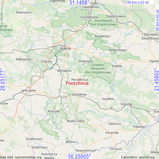
Pierzchnica GPS coordinates[2]
50° 41' 51.144" North, 20° 45' 17.604" East
| Map corner | latitude | longitude |
|---|---|---|
| Upper-left | 51.1408°, | 20.05177° |
| Center: | 50.69754°, | 20.75489° |
| Lower-right: | 50.25005°, | 21.45802° |
| Map W x H: | 99×99 km | = 61.5×61.5mi |
| max Lat: | 54.83135° ⇑62.6% North |
| Pierzchnica: | 50.69754° |
| min Lat: | ⇓37.4% South 49.21328° |
| min Long | Pierzchnica | max Long |
| 14.20249° | 20.75489° | 24.03723° |
| W 68.5%⇐ | ⇒31.5% E |
Elevation
Elevation of Pierzchnica is 274 m = 899 ft, and this is 82.6 m = 271 ft above average elevation for this country.
| Max E: |
974 m = 3196 ft | 18.3% |
| Pierzchnica | 274 m 899 ft | |
| Avg. | 191.4 m = 628 ft | |
Min E: |
-3 m = -10 ft | 81.7% |
See also: Poland elevation on elevation.city.
Geographical zone
Pierzchnica is located in North temperate zone (between Tropic of Cancer and the Arctic Circle). Distance of this North polar circle is 1764.1 km =1096.2 mi to North.| Distance of | km | miles | from Pierzchnica |
|---|---|---|---|
| North Pole | 4370 | 2715.4 | to North |
| Arctic Circle | 1764.1 | 1096.2 | to North |
| Tropic Cancer | 3031.1 | 1883.4 | to South |
| Equator | 5637 | 3502.7 | to South |


Nearby cities:
15 places around Pierzchnica: (largest is in red/bold)
• Brzeziny
15.3 km =9.5 mi,  303°
303°
• Chmielnik
9.2 km =5.7 mi,  181°
181°
• Daleszyce
12.2 km =7.6 mi,  17°
17°
• Domaszowice
20.4 km =12.7 mi,  345°
345°
• Gnojno
12.5 km =7.8 mi,  147°
147°
• Górno
17.4 km =10.8 mi, 16°
• Kielce
21.2 km =13.2 mi,  335°
335°
• Kije
16.4 km =10.2 mi,  232°
232°
• Korytnica
17.5 km =10.9 mi,  255°
255°
• Morawica
11.1 km =6.9 mi, 299°
• Osiedle-Nowiny
20.1 km =12.5 mi,  311°
311°
• Raków
20.6 km =12.8 mi,  97°
97°
• Siedlce
19.2 km =11.9 mi,  285°
285°
• Wola Jachowa
18 km =11.2 mi, 23°
• Łukowa
15.5 km =9.6 mi,  281°
281°
Sources, notices
• [Note1] Compared only with cities in Poland existing in our database
• [Src1] Map data: © OpenStreetMap contributors (CC-BY-SA)
• [Src2] Other city data from geonames.org with taken over terms of usage.
• [Src3] Geographical zone / Annual Mean Temperature by Robert A. Rohde @ Wikipedia
