Bogoria geodata
Bogoria (Świętokrzyskie) is a seat of a third-order administrative division; located in Poland in Europe/Warsaw (GMT+2) time zone. With population of 930 people, there are 2620 cities with bigger population in this country. Compared to other cities in Poland, 63.9% of cities are located further ↑North; 76.5% of cities are located further ←West and 79% of cities have lower elevation than Bogoria. Note1


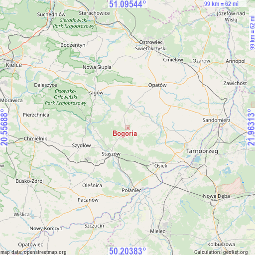
Bogoria GPS coordinates[2]
50° 39' 6.3" North, 21° 15' 36" East
| Map corner | latitude | longitude |
|---|---|---|
| Upper-left | 51.09544°, | 20.55688° |
| Center: | 50.65175°, | 21.26° |
| Lower-right: | 50.20383°, | 21.96313° |
| Map W x H: | 99.1×99.1 km | = 61.6×61.6mi |
| max Lat: | 54.83135° ⇑63.9% North |
| Bogoria: | 50.65175° |
| min Lat: | ⇓36.1% South 49.21328° |
| min Long | Bogoria | max Long |
| 14.20249° | 21.26° | 24.03723° |
| W 76.5%⇐ | ⇒23.5% E |
Elevation
Elevation of Bogoria is 261 m = 856 ft, and this is 69.6 m = 228 ft above average elevation for this country.
| Max E: |
974 m = 3196 ft | 21% |
| Bogoria | 261 m 856 ft | |
| Avg. | 191.4 m = 628 ft | |
Min E: |
-3 m = -10 ft | 79% |
See also: Poland elevation on elevation.city.
Geographical zone
Bogoria is located in North temperate zone (between Tropic of Cancer and the Arctic Circle). Distance of this North polar circle is 1769.2 km =1099.3 mi to North.| Distance of | km | miles | from Bogoria |
|---|---|---|---|
| North Pole | 4375.1 | 2718.6 | to North |
| Arctic Circle | 1769.2 | 1099.3 | to North |
| Tropic Cancer | 3026 | 1880.3 | to South |
| Equator | 5631.9 | 3499.5 | to South |


Nearby cities:
15 places around Bogoria: (largest is in red/bold)
• Baćkowice
15.7 km =9.8 mi,  352°
352°
• Iwaniska
9 km =5.6 mi,  9°
9°
• Klimontów
13.8 km =8.6 mi,  88°
88°
• Lipnik
18.6 km =11.6 mi,  62°
62°
• Opatów
20.2 km =12.6 mi,  35°
35°
• Osiek
19.5 km =12.1 mi,  138°
138°
• Raków
15.3 km =9.5 mi,  279°
279°
• Rytwiany
14.1 km =8.8 mi,  195°
195°
• Staszów
11.9 km =7.4 mi,  213°
213°
• Szydłów
19.1 km =11.9 mi,  249°
249°
• Wiśniowa
6.5 km =4 mi,  185°
185°
• Wiśniowa
21 km =13 mi,  325°
325°
• Łagów
18.5 km =11.5 mi,  317°
317°
• Łoniów
21.1 km =13.1 mi,  117°
117°
• Świniary Stare
23 km =14.3 mi, 123°
Sources, notices
• [Note1] Compared only with cities in Poland existing in our database
• [Src1] Map data: © OpenStreetMap contributors (CC-BY-SA)
• [Src2] Other city data from geonames.org with taken over terms of usage.
• [Src3] Geographical zone / Annual Mean Temperature by Robert A. Rohde @ Wikipedia
