Łagów geodata
Łagów (Świętokrzyskie) is a seat of a third-order administrative division; located in Poland in Europe/Warsaw (GMT+2) time zone. With population of 1,630 people, there are 1732 cities with bigger population in this country. Compared to other cities in Poland, 60.7% of cities are located further ↑North; 74.2% of cities are located further ←West and 86.2% of cities have lower elevation than Łagów. Note1


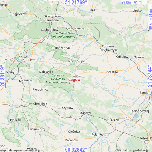
Łagów GPS coordinates[2]
50° 46' 30.612" North, 21° 5' 3.516" East
| Map corner | latitude | longitude |
|---|---|---|
| Upper-left | 51.21769°, | 20.38119° |
| Center: | 50.77517°, | 21.08431° |
| Lower-right: | 50.32842°, | 21.78744° |
| Map W x H: | 98.9×98.9 km | = 61.5×61.5mi |
| max Lat: | 54.83135° ⇑60.7% North |
| Łagów: | 50.77517° |
| min Lat: | ⇓39.3% South 49.21328° |
| min Long | Łagów | max Long |
| 14.20249° | 21.08431° | 24.03723° |
| W 74.2%⇐ | ⇒25.8% E |
Elevation
Elevation of Łagów is 297 m = 974 ft, and this is 105.6 m = 346 ft above average elevation for this country.
| Max E: |
974 m = 3196 ft | 13.8% |
| Łagów | 297 m 974 ft | |
| Avg. | 191.4 m = 628 ft | |
Min E: |
-3 m = -10 ft | 86.2% |
See also: Poland elevation on elevation.city.
Geographical zone
Łagów is located in North temperate zone (between Tropic of Cancer and the Arctic Circle). Distance of this North polar circle is 1755.5 km =1090.8 mi to North.| Distance of | km | miles | from Łagów |
|---|---|---|---|
| North Pole | 4361.4 | 2710 | to North |
| Arctic Circle | 1755.5 | 1090.8 | to North |
| Tropic Cancer | 3039.8 | 1888.8 | to South |
| Equator | 5645.7 | 3508.1 | to South |


Nearby cities:
15 places around Łagów: (largest is in red/bold)
• Baćkowice
10.6 km =6.6 mi,  79°
79°
• Bieliny
13 km =8.1 mi,  309°
309°
• Bodzentyn
20.5 km =12.7 mi,  334°
334°
• Bogoria
18.5 km =11.5 mi,  137°
137°
• Daleszyce
19.7 km =12.2 mi,  278°
278°
• Górno
19.9 km =12.4 mi,  293°
293°
• Iwaniska
14.6 km =9.1 mi,  109°
109°
• Nowa Słupia
9.9 km =6.2 mi,  2°
2°
• Pawłów
20.9 km =13 mi,  6°
6°
• Raków
11.6 km =7.2 mi,  193°
193°
• Sosnówka
14.2 km =8.8 mi, 0°
• Stara Słupia
11.5 km =7.1 mi, 12°
• Waśniów
16.9 km =10.5 mi,  35°
35°
• Wiśniowa
3.5 km =2.2 mi, 5°
• Wola Jachowa
17.7 km =11 mi,  296°
296°
Sources, notices
• [Note1] Compared only with cities in Poland existing in our database
• [Src1] Map data: © OpenStreetMap contributors (CC-BY-SA)
• [Src2] Other city data from geonames.org with taken over terms of usage.
• [Src3] Geographical zone / Annual Mean Temperature by Robert A. Rohde @ Wikipedia
