Szudziałowo geodata
Szudziałowo (Podlasie) is a populated place; located in Poland in Europe/Warsaw (GMT+2) time zone. With population of 650 people, there are 3162 cities with bigger population in this country. Compared to other cities in Poland, 87.4% of cities are located further ↓South; 99.4% of cities are located further ←West and 51.9% of cities have higher elevation than Szudziałowo. Note1


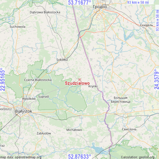
Szudziałowo GPS coordinates[2]
53° 17' 55.032" North, 23° 39' 17.172" East
| Map corner | latitude | longitude |
|---|---|---|
| Upper-left | 53.71677°, | 22.95165° |
| Center: | 53.29862°, | 23.65477° |
| Lower-right: | 52.87633°, | 24.3579° |
| Map W x H: | 93.4×93.4 km | = 58×58mi |
| max Lat: | 54.83135° ⇑12.6% North |
| Szudziałowo: | 53.29862° |
| min Lat: | ⇓87.4% South 49.21328° |
| min Long | Szudziałowo | max Long |
| 14.20249° | 23.65477° | 24.03723° |
| W 99.4%⇐ | ⇒0.59999999999999% E |
Elevation
Elevation of Szudziałowo is 167 m = 548 ft, and this is 24.4 m = 80 ft below average elevation for this country.
| Max E: |
974 m = 3196 ft | 51.9% |
| Avg. | 191.4 m = 628 ft | |
| Szudziałowo | 167 m = 548 ft | |
Min E: |
-3 m = -10 ft | 48.1% |
See also: Poland elevation on elevation.city.
Geographical zone
Szudziałowo is located in North temperate zone (between Tropic of Cancer and the Arctic Circle). Distance of this North polar circle is 1474.9 km =916.5 mi to North.| Distance of | km | miles | from Szudziałowo |
|---|---|---|---|
| North Pole | 4080.8 | 2535.7 | to North |
| Arctic Circle | 1474.9 | 916.5 | to North |
| Tropic Cancer | 3320.3 | 2063.1 | to South |
| Equator | 5926.3 | 3682.4 | to South |


Nearby cities:
15 places around Szudziałowo: (largest is in red/bold)
• Białystok
37.5 km =23.3 mi,  240°
240°
• Czarna Białostocka
24.8 km =15.4 mi,  271°
271°
• Grudki
22.7 km =14.1 mi,  177°
177°
• Janów
33.8 km =21 mi,  303°
303°
• Jasionówka
42.4 km =26.3 mi,  284°
284°
• Korycin
40.8 km =25.4 mi,  293°
293°
• Krynki
8.7 km =5.4 mi,  115°
115°
• Kuźnica
23.6 km =14.7 mi,  359°
359°
• Michałowo
29.5 km =18.3 mi,  185°
185°
• Nowy Dwór
37.8 km =23.5 mi,  348°
348°
• Sidra
31.3 km =19.4 mi,  334°
334°
• Sokółka
15.7 km =9.8 mi,  320°
320°
• Supraśl
23.4 km =14.5 mi, 243°
• Wasilków
31.7 km =19.7 mi,  249°
249°
• Zabłudów
38 km =23.6 mi,  213°
213°
Sources, notices
• [Note1] Compared only with cities in Poland existing in our database
• [Src1] Map data: © OpenStreetMap contributors (CC-BY-SA)
• [Src2] Other city data from geonames.org with taken over terms of usage.
• [Src3] Geographical zone / Annual Mean Temperature by Robert A. Rohde @ Wikipedia
