Krynki geodata
Krynki (Podlasie) is a seat of a third-order administrative division; located in Poland in Europe/Warsaw (GMT+2) time zone. With population of 2,700 people, there are 1159 cities with bigger population in this country. Compared to other cities in Poland, 87.1% of cities are located further ↓South; 99.7% of cities are located further ←West and 56.4% of cities have higher elevation than Krynki. Note1


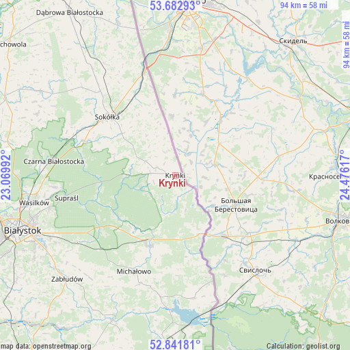
Krynki GPS coordinates[2]
53° 15' 51.984" North, 23° 46' 22.944" East
| Map corner | latitude | longitude |
|---|---|---|
| Upper-left | 53.68293°, | 23.06992° |
| Center: | 53.26444°, | 23.77304° |
| Lower-right: | 52.84181°, | 24.47617° |
| Map W x H: | 93.5×93.5 km | = 58.1×58.1mi |
| max Lat: | 54.83135° ⇑12.9% North |
| Krynki: | 53.26444° |
| min Lat: | ⇓87.1% South 49.21328° |
| min Long | Krynki | max Long |
| 14.20249° | 23.77304° | 24.03723° |
| W 99.7%⇐ | ⇒0.3% E |
Elevation
Elevation of Krynki is 155 m = 509 ft, and this is 36.4 m = 119 ft below average elevation for this country.
| Max E: |
974 m = 3196 ft | 56.4% |
| Avg. | 191.4 m = 628 ft | |
| Krynki | 155 m = 509 ft | |
Min E: |
-3 m = -10 ft | 43.6% |
See also: Poland elevation on elevation.city.
Geographical zone
Krynki is located in North temperate zone (between Tropic of Cancer and the Arctic Circle). Distance of this North polar circle is 1478.7 km =918.8 mi to North.| Distance of | km | miles | from Krynki |
|---|---|---|---|
| North Pole | 4084.6 | 2538.1 | to North |
| Arctic Circle | 1478.7 | 918.8 | to North |
| Tropic Cancer | 3316.5 | 2060.8 | to South |
| Equator | 5922.5 | 3680.1 | to South |


Nearby cities:
15 places around Krynki: (largest is in red/bold)
• Białystok
43.1 km =26.8 mi,  250°
250°
• Czarna Białostocka
33 km =20.5 mi,  277°
277°
• Grudki
20.1 km =12.5 mi,  200°
200°
• Janów
42.5 km =26.4 mi,  302°
302°
• Kuźnica
28.6 km =17.8 mi,  343°
343°
• Michałowo
27.7 km =17.2 mi, 203°
• Narew
42.5 km =26.4 mi, 203°
• Narewka
48 km =29.8 mi,  180°
180°
• Nowy Dwór
43.6 km =27.1 mi, 339°
• Sidra
38.5 km =23.9 mi,  326°
326°
• Sokółka
24 km =14.9 mi,  311°
311°
• Supraśl
29.6 km =18.4 mi,  257°
257°
• Szudziałowo
8.7 km =5.4 mi, 295°
• Wasilków
38.3 km =23.8 mi, 259°
• Zabłudów
40.2 km =25 mi,  226°
226°
Sources, notices
• [Note1] Compared only with cities in Poland existing in our database
• [Src1] Map data: © OpenStreetMap contributors (CC-BY-SA)
• [Src2] Other city data from geonames.org with taken over terms of usage.
• [Src3] Geographical zone / Annual Mean Temperature by Robert A. Rohde @ Wikipedia
