Michałowo geodata
Michałowo (Podlasie) is a seat of a third-order administrative division; located in Poland in Europe/Warsaw (GMT+2) time zone. With population of 3,621 people, there are 887 cities with bigger population in this country. Compared to other cities in Poland, 84.1% of cities are located further ↓South; 99.2% of cities are located further ←West and 56.4% of cities have higher elevation than Michałowo. Note1


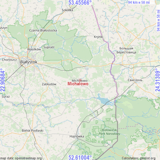
Michałowo GPS coordinates[2]
53° 2' 5.712" North, 23° 36' 35.856" East
| Map corner | latitude | longitude |
|---|---|---|
| Upper-left | 53.45566°, | 22.90684° |
| Center: | 53.03492°, | 23.60996° |
| Lower-right: | 52.61004°, | 24.31309° |
| Map W x H: | 94×94 km | = 58.4×58.4mi |
| max Lat: | 54.83135° ⇑15.9% North |
| Michałowo: | 53.03492° |
| min Lat: | ⇓84.1% South 49.21328° |
| min Long | Michałowo | max Long |
| 14.20249° | 23.60996° | 24.03723° |
| W 99.2%⇐ | ⇒0.8% E |
Elevation
Elevation of Michałowo is 155 m = 509 ft, and this is 36.4 m = 119 ft below average elevation for this country.
| Max E: |
974 m = 3196 ft | 56.4% |
| Avg. | 191.4 m = 628 ft | |
| Michałowo | 155 m = 509 ft | |
Min E: |
-3 m = -10 ft | 43.6% |
See also: Poland elevation on elevation.city.
Geographical zone
Michałowo is located in North temperate zone (between Tropic of Cancer and the Arctic Circle). Distance of this North polar circle is 1504.2 km =934.7 mi to North.| Distance of | km | miles | from Michałowo |
|---|---|---|---|
| North Pole | 4110.1 | 2553.9 | to North |
| Arctic Circle | 1504.2 | 934.7 | to North |
| Tropic Cancer | 3291 | 2044.9 | to South |
| Equator | 5896.9 | 3664.2 | to South |


Nearby cities:
15 places around Michałowo: (largest is in red/bold)
• Białowieża
41 km =25.5 mi,  155°
155°
• Białystok
31.7 km =19.7 mi,  290°
290°
• Czarna Białostocka
37.2 km =23.1 mi,  323°
323°
• Czyże
31.9 km =19.8 mi,  203°
203°
• Grudki
7.7 km =4.8 mi,  30°
30°
• Hajnówka
32.5 km =20.2 mi,  183°
183°
• Krynki
27.7 km =17.2 mi,  23°
23°
• Narew
14.7 km =9.1 mi, 204°
• Narewka
24.7 km =15.3 mi, 155°
• Orla
41.1 km =25.5 mi,  206°
206°
• Supraśl
26.2 km =16.3 mi, 316°
• Szudziałowo
29.5 km =18.3 mi,  5°
5°
• Turośń Kościelna
37.2 km =23.1 mi,  266°
266°
• Wasilków
32.5 km =20.2 mi,  304°
304°
• Zabłudów
18.3 km =11.4 mi,  262°
262°
Sources, notices
• [Note1] Compared only with cities in Poland existing in our database
• [Src1] Map data: © OpenStreetMap contributors (CC-BY-SA)
• [Src2] Other city data from geonames.org with taken over terms of usage.
• [Src3] Geographical zone / Annual Mean Temperature by Robert A. Rohde @ Wikipedia
