Grudki geodata
Grudki (Podlasie) is a populated place; located in Poland in Europe/Warsaw (GMT+2) time zone. With population of 5,822 people, there are 619 cities with bigger population in this country. Compared to other cities in Poland, 84.8% of cities are located further ↓South; 99.4% of cities are located further ←West and 61.1% of cities have higher elevation than Grudki. Note1


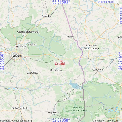
Grudki GPS coordinates[2]
53° 5' 41.568" North, 23° 40' 6.528" East
| Map corner | latitude | longitude |
|---|---|---|
| Upper-left | 53.51503°, | 22.96536° |
| Center: | 53.09488°, | 23.66848° |
| Lower-right: | 52.67058°, | 24.37161° |
| Map W x H: | 93.9×93.9 km | = 58.3×58.3mi |
| max Lat: | 54.83135° ⇑15.2% North |
| Grudki: | 53.09488° |
| min Lat: | ⇓84.8% South 49.21328° |
| min Long | Grudki | max Long |
| 14.20249° | 23.66848° | 24.03723° |
| W 99.4%⇐ | ⇒0.59999999999999% E |
Elevation
Elevation of Grudki is 144 m = 472 ft, and this is 47.4 m = 156 ft below average elevation for this country.
| Max E: |
974 m = 3196 ft | 61.1% |
| Avg. | 191.4 m = 628 ft | |
| Grudki | 144 m = 472 ft | |
Min E: |
-3 m = -10 ft | 38.9% |
See also: Poland elevation on elevation.city.
Geographical zone
Grudki is located in North temperate zone (between Tropic of Cancer and the Arctic Circle). Distance of this North polar circle is 1497.6 km =930.6 mi to North.| Distance of | km | miles | from Grudki |
|---|---|---|---|
| North Pole | 4103.5 | 2549.8 | to North |
| Arctic Circle | 1497.6 | 930.6 | to North |
| Tropic Cancer | 3297.7 | 2049.1 | to South |
| Equator | 5903.6 | 3668.3 | to South |


Nearby cities:
15 places around Grudki: (largest is in red/bold)
• Białystok
33.9 km =21.1 mi,  277°
277°
• Czarna Białostocka
34.8 km =21.6 mi,  312°
312°
• Czyże
39.6 km =24.6 mi,  204°
204°
• Dobrzyniewo Duże
45.4 km =28.2 mi, 284°
• Hajnówka
39.5 km =24.5 mi,  188°
188°
• Krynki
20.1 km =12.5 mi,  20°
20°
• Michałowo
7.7 km =4.8 mi,  210°
210°
• Narew
22.4 km =13.9 mi, 206°
• Narewka
29.8 km =18.5 mi,  167°
167°
• Sokółka
36.4 km =22.6 mi,  342°
342°
• Supraśl
25.1 km =15.6 mi,  299°
299°
• Szudziałowo
22.7 km =14.1 mi,  357°
357°
• Turośń Kościelna
41.9 km =26 mi,  257°
257°
• Wasilków
32.8 km =20.4 mi,  290°
290°
• Zabłudów
23.8 km =14.8 mi,  247°
247°
Sources, notices
• [Note1] Compared only with cities in Poland existing in our database
• [Src1] Map data: © OpenStreetMap contributors (CC-BY-SA)
• [Src2] Other city data from geonames.org with taken over terms of usage.
• [Src3] Geographical zone / Annual Mean Temperature by Robert A. Rohde @ Wikipedia
