Bychawa geodata
Bychawa (Lublin) is a seat of a third-order administrative division; located in Poland in Europe/Warsaw (GMT+2) time zone. With population of 5,297 people, there are 655 cities with bigger population in this country. Compared to other cities in Poland, 55% of cities are located further ↑North; 92.1% of cities are located further ←West and 65.3% of cities have lower elevation than Bychawa. Note1


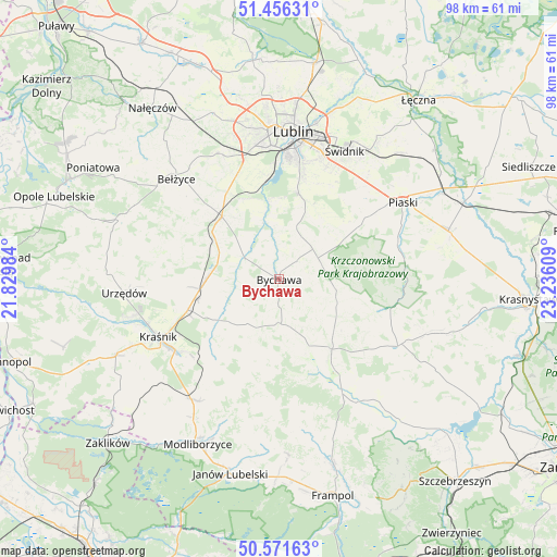
Bychawa GPS coordinates[2]
51° 0' 57.888" North, 22° 31' 58.656" East
| Map corner | latitude | longitude |
|---|---|---|
| Upper-left | 51.45631°, | 21.82984° |
| Center: | 51.01608°, | 22.53296° |
| Lower-right: | 50.57163°, | 23.23609° |
| Map W x H: | 98.4×98.4 km | = 61.1×61.1mi |
| max Lat: | 54.83135° ⇑55% North |
| Bychawa: | 51.01608° |
| min Lat: | ⇓45% South 49.21328° |
| min Long | Bychawa | max Long |
| 14.20249° | 22.53296° | 24.03723° |
| W 92.1%⇐ | ⇒7.9% E |
Elevation
Elevation of Bychawa is 215 m = 705 ft, and this is 23.6 m = 77 ft above average elevation for this country.
| Max E: |
974 m = 3196 ft | 34.7% |
| Bychawa | 215 m 705 ft | |
| Avg. | 191.4 m = 628 ft | |
Min E: |
-3 m = -10 ft | 65.3% |
See also: Poland elevation on elevation.city.
Geographical zone
Bychawa is located in North temperate zone (between Tropic of Cancer and the Arctic Circle). Distance of this North polar circle is 1728.7 km =1074.2 mi to North.| Distance of | km | miles | from Bychawa |
|---|---|---|---|
| North Pole | 4334.6 | 2693.4 | to North |
| Arctic Circle | 1728.7 | 1074.2 | to North |
| Tropic Cancer | 3066.5 | 1905.4 | to South |
| Equator | 5672.5 | 3524.7 | to South |


Nearby cities:
15 places around Bychawa: (largest is in red/bold)
• Batorz
18.6 km =11.6 mi,  188°
188°
• Borzechów
19.4 km =12.1 mi,  296°
296°
• Bystrzyca
9.2 km =5.7 mi,  251°
251°
• Jabłonna
9.1 km =5.7 mi,  27°
27°
• Krzczonów
12.5 km =7.8 mi,  94°
94°
• Niedrzwica Duża
14.9 km =9.3 mi,  317°
317°
• Rudnik Pierwszy
8.9 km =5.5 mi,  227°
227°
• Rybczewice
22.3 km =13.9 mi, 86°
• Strzyżowice
7.4 km =4.6 mi, 298°
• Sułów
17.1 km =10.6 mi,  224°
224°
• Wilkołaz
12.8 km =8 mi,  269°
269°
• Wysokie
14.9 km =9.3 mi,  141°
141°
• Zakrzew
14.6 km =9.1 mi,  163°
163°
• Zakrzówek
12.8 km =8 mi,  235°
235°
• Żabia Wola
11.6 km =7.2 mi,  353°
353°
Sources, notices
• [Note1] Compared only with cities in Poland existing in our database
• [Src1] Map data: © OpenStreetMap contributors (CC-BY-SA)
• [Src2] Other city data from geonames.org with taken over terms of usage.
• [Src3] Geographical zone / Annual Mean Temperature by Robert A. Rohde @ Wikipedia
