Sułkowice geodata
Sułkowice (Mazovia) is a populated place; located in Poland in Europe/Warsaw (GMT+2) time zone. With population of 1,100 people, there are 2307 cities with bigger population in this country. Compared to other cities in Poland, 64.2% of cities are located further ↓South; 74.3% of cities are located further ←West and 74.5% of cities have higher elevation than Sułkowice. Note1


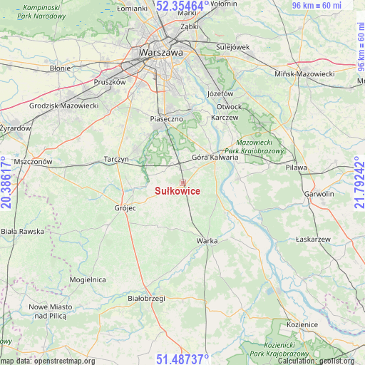
Sułkowice GPS coordinates[2]
51° 55' 23.16" North, 21° 5' 21.444" East
| Map corner | latitude | longitude |
|---|---|---|
| Upper-left | 52.35464°, | 20.38617° |
| Center: | 51.9231°, | 21.08929° |
| Lower-right: | 51.48737°, | 21.79242° |
| Map W x H: | 96.4×96.4 km | = 59.9×59.9mi |
| max Lat: | 54.83135° ⇑35.8% North |
| Sułkowice: | 51.9231° |
| min Lat: | ⇓64.2% South 49.21328° |
| min Long | Sułkowice | max Long |
| 14.20249° | 21.08929° | 24.03723° |
| W 74.3%⇐ | ⇒25.7% E |
Elevation
Elevation of Sułkowice is 112 m = 367 ft, and this is 79.4 m = 260 ft below average elevation for this country.
| Max E: |
974 m = 3196 ft | 74.5% |
| Avg. | 191.4 m = 628 ft | |
| Sułkowice | 112 m = 367 ft | |
Min E: |
-3 m = -10 ft | 25.5% |
See also: Poland elevation on elevation.city.
Geographical zone
Sułkowice is located in North temperate zone (between Tropic of Cancer and the Arctic Circle). Distance of this North polar circle is 1627.9 km =1011.5 mi to North.| Distance of | km | miles | from Sułkowice |
|---|---|---|---|
| North Pole | 4233.8 | 2630.8 | to North |
| Arctic Circle | 1627.9 | 1011.5 | to North |
| Tropic Cancer | 3167.4 | 1968.1 | to South |
| Equator | 5773.3 | 3587.4 | to South |


Nearby cities:
15 places around Sułkowice: (largest is in red/bold)
• Baniocha
11 km =6.8 mi,  18°
18°
• Chynów
2.2 km =1.4 mi,  193°
193°
• Czarnów
14.8 km =9.2 mi,  2°
2°
• Czersk
10.5 km =6.5 mi,  67°
67°
• Gołków
15.5 km =9.6 mi,  328°
328°
• Grójec
16.6 km =10.3 mi,  246°
246°
• Góra Kalwaria
10.5 km =6.5 mi,  55°
55°
• Jasieniec
15.2 km =9.4 mi,  221°
221°
• Jazgarzew
14.4 km =8.9 mi, 333°
• Kamionka
16.7 km =10.4 mi, 333°
• Prażmów
9.4 km =5.8 mi,  281°
281°
• Sobienie Jeziory
14.7 km =9.1 mi,  85°
85°
• Warka
16.9 km =10.5 mi,  155°
155°
• Zalesie Górne
12.2 km =7.6 mi,  342°
342°
• Żabieniec
15.3 km =9.5 mi,  349°
349°
Sources, notices
• [Note1] Compared only with cities in Poland existing in our database
• [Src1] Map data: © OpenStreetMap contributors (CC-BY-SA)
• [Src2] Other city data from geonames.org with taken over terms of usage.
• [Src3] Geographical zone / Annual Mean Temperature by Robert A. Rohde @ Wikipedia
