Rajgród geodata
Rajgród (Podlasie) is a populated place; located in Poland in Europe/Warsaw (GMT+2) time zone. With population of 1,732 people, there are 1658 cities with bigger population in this country. Compared to other cities in Poland, 91.7% of cities are located further ↓South; 93.9% of cities are located further ←West and 69.8% of cities have higher elevation than Rajgród. Note1


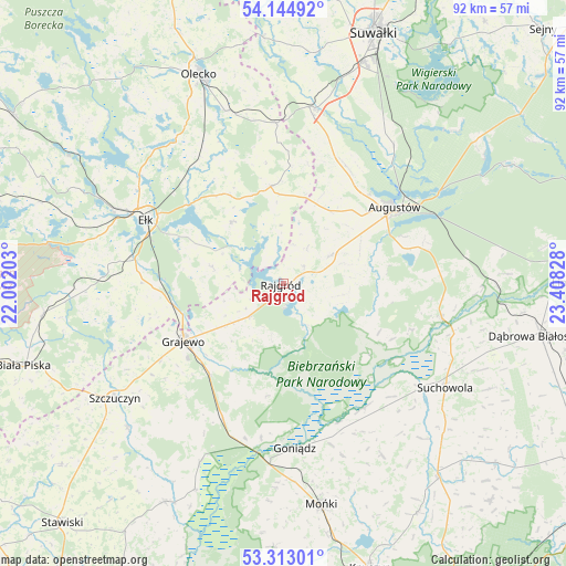
Rajgród GPS coordinates[2]
53° 43' 51.672" North, 22° 42' 18.54" East
| Map corner | latitude | longitude |
|---|---|---|
| Upper-left | 54.14492°, | 22.00203° |
| Center: | 53.73102°, | 22.70515° |
| Lower-right: | 53.31301°, | 23.40828° |
| Map W x H: | 92.5×92.5 km | = 57.5×57.5mi |
| max Lat: | 54.83135° ⇑8.3% North |
| Rajgród: | 53.73102° |
| min Lat: | ⇓91.7% South 49.21328° |
| min Long | Rajgród | max Long |
| 14.20249° | 22.70515° | 24.03723° |
| W 93.9%⇐ | ⇒6.1% E |
Elevation
Elevation of Rajgród is 121 m = 397 ft, and this is 70.4 m = 231 ft below average elevation for this country.
| Max E: |
974 m = 3196 ft | 69.8% |
| Avg. | 191.4 m = 628 ft | |
| Rajgród | 121 m = 397 ft | |
Min E: |
-3 m = -10 ft | 30.2% |
See also: Poland elevation on elevation.city.
Geographical zone
Rajgród is located in North temperate zone (between Tropic of Cancer and the Arctic Circle). Distance of this North polar circle is 1426.8 km =886.6 mi to North.| Distance of | km | miles | from Rajgród |
|---|---|---|---|
| North Pole | 4032.7 | 2505.8 | to North |
| Arctic Circle | 1426.8 | 886.6 | to North |
| Tropic Cancer | 3368.4 | 2093 | to South |
| Equator | 5974.3 | 3712.3 | to South |


Nearby cities:
15 places around Rajgród: (largest is in red/bold)
• Augustów
21.9 km =13.6 mi,  55°
55°
• Bargłów Kościelny
9.1 km =5.7 mi, 58°
• Ełk
24.8 km =15.4 mi,  295°
295°
• Goniadz
26.9 km =16.7 mi,  175°
175°
• Grajewo
18.9 km =11.7 mi,  240°
240°
• Jaświły
32.3 km =20.1 mi,  150°
150°
• Kalinowo
16.1 km =10 mi,  352°
352°
• Olecko
36.1 km =22.4 mi,  338°
338°
• Prostki
18.3 km =11.4 mi,  258°
258°
• Raczki
29 km =18 mi,  10°
10°
• Suchowola
31.4 km =19.5 mi,  122°
122°
• Szczuczyn
33.4 km =20.8 mi, 236°
• Sztabin
26.4 km =16.4 mi,  101°
101°
• Wieliczki
29.7 km =18.5 mi, 341°
• Wąsosz
34.5 km =21.4 mi,  227°
227°
Sources, notices
• [Note1] Compared only with cities in Poland existing in our database
• [Src1] Map data: © OpenStreetMap contributors (CC-BY-SA)
• [Src2] Other city data from geonames.org with taken over terms of usage.
• [Src3] Geographical zone / Annual Mean Temperature by Robert A. Rohde @ Wikipedia
