Prostki geodata
Prostki (Warmia-Masuria) is a populated place; located in Poland in Europe/Warsaw (GMT+2) time zone. With population of 2,541 people, there are 1225 cities with bigger population in this country. Compared to other cities in Poland, 91.4% of cities are located further ↓South; 90.6% of cities are located further ←West and 71.6% of cities have higher elevation than Prostki. Note1


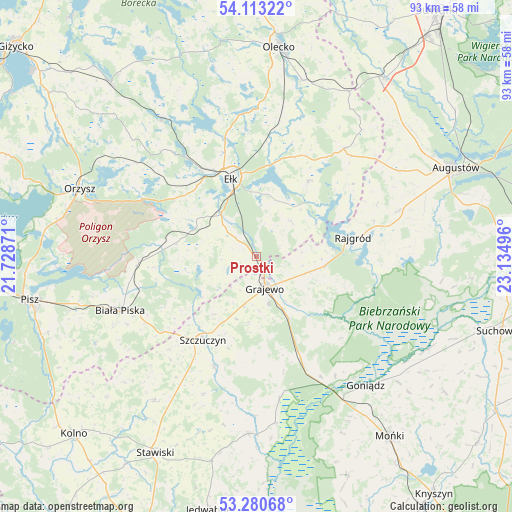
Prostki GPS coordinates[2]
53° 41' 56.436" North, 22° 25' 54.588" East
| Map corner | latitude | longitude |
|---|---|---|
| Upper-left | 54.11322°, | 21.72871° |
| Center: | 53.69901°, | 22.43183° |
| Lower-right: | 53.28068°, | 23.13496° |
| Map W x H: | 92.6×92.6 km | = 57.5×57.5mi |
| max Lat: | 54.83135° ⇑8.6% North |
| Prostki: | 53.69901° |
| min Lat: | ⇓91.4% South 49.21328° |
| min Long | Prostki | max Long |
| 14.20249° | 22.43183° | 24.03723° |
| W 90.6%⇐ | ⇒9.4% E |
Elevation
Elevation of Prostki is 118 m = 387 ft, and this is 73.4 m = 241 ft below average elevation for this country.
| Max E: |
974 m = 3196 ft | 71.6% |
| Avg. | 191.4 m = 628 ft | |
| Prostki | 118 m = 387 ft | |
Min E: |
-3 m = -10 ft | 28.4% |
See also: Poland elevation on elevation.city.
Geographical zone
Prostki is located in North temperate zone (between Tropic of Cancer and the Arctic Circle). Distance of this North polar circle is 1430.4 km =888.8 mi to North.| Distance of | km | miles | from Prostki |
|---|---|---|---|
| North Pole | 4036.3 | 2508 | to North |
| Arctic Circle | 1430.4 | 888.8 | to North |
| Tropic Cancer | 3364.9 | 2090.9 | to South |
| Equator | 5970.8 | 3710.1 | to South |


Nearby cities:
15 places around Prostki: (largest is in red/bold)
• Bargłów Kościelny
27 km =16.8 mi,  72°
72°
• Biała Piska
26.1 km =16.2 mi,  248°
248°
• Ełk
15 km =9.3 mi,  342°
342°
• Goniadz
30.7 km =19.1 mi,  139°
139°
• Grabowo
31.7 km =19.7 mi,  215°
215°
• Grajewo
6 km =3.7 mi,  164°
164°
• Kalinowo
25.1 km =15.6 mi,  38°
38°
• Orzysz
34.1 km =21.2 mi,  291°
291°
• Radziłów
32.2 km =20 mi,  182°
182°
• Rajgród
18.3 km =11.4 mi,  78°
78°
• Stare Juchy
30 km =18.6 mi,  325°
325°
• Swiętajno
34.4 km =21.4 mi,  347°
347°
• Szczuczyn
17.9 km =11.1 mi,  212°
212°
• Wieliczki
32.9 km =20.4 mi,  15°
15°
• Wąsosz
21 km =13 mi,  200°
200°
Sources, notices
• [Note1] Compared only with cities in Poland existing in our database
• [Src1] Map data: © OpenStreetMap contributors (CC-BY-SA)
• [Src2] Other city data from geonames.org with taken over terms of usage.
• [Src3] Geographical zone / Annual Mean Temperature by Robert A. Rohde @ Wikipedia
