Liw geodata
Liw (Mazovia) is a seat of a third-order administrative division; located in Poland in Europe/Warsaw (GMT+2) time zone. In our database, there are 3649 cities with bigger population. Compared to other cities in Poland, 74.2% of cities are located further ↓South; 84.5% of cities are located further ←West and 69.3% of cities have higher elevation than Liw. Note1


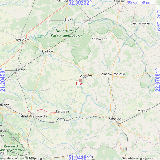
Liw GPS coordinates[2]
52° 22' 30.54" North, 21° 58' 3.648" East
| Map corner | latitude | longitude |
|---|---|---|
| Upper-left | 52.80232°, | 21.26456° |
| Center: | 52.37515°, | 21.96768° |
| Lower-right: | 51.94381°, | 22.67081° |
| Map W x H: | 95.5×95.5 km | = 59.3×59.3mi |
| max Lat: | 54.83135° ⇑25.8% North |
| Liw: | 52.37515° |
| min Lat: | ⇓74.2% South 49.21328° |
| min Long | Liw | max Long |
| 14.20249° | 21.96768° | 24.03723° |
| W 84.5%⇐ | ⇒15.5% E |
Elevation
Elevation of Liw is 122 m = 400 ft, and this is 69.4 m = 228 ft below average elevation for this country.
| Max E: |
974 m = 3196 ft | 69.3% |
| Avg. | 191.4 m = 628 ft | |
| Liw | 122 m = 400 ft | |
Min E: |
-3 m = -10 ft | 30.7% |
See also: Poland elevation on elevation.city.
Geographical zone
Liw is located in North temperate zone (between Tropic of Cancer and the Arctic Circle). Distance of this North polar circle is 1577.6 km =980.3 mi to North.| Distance of | km | miles | from Liw |
|---|---|---|---|
| North Pole | 4183.5 | 2599.5 | to North |
| Arctic Circle | 1577.6 | 980.3 | to North |
| Tropic Cancer | 3217.7 | 1999.4 | to South |
| Equator | 5823.6 | 3618.6 | to South |


Nearby cities:
15 places around Liw: (largest is in red/bold)
• Bielany
19.5 km =12.1 mi,  100°
100°
• Dobre
20.5 km =12.7 mi,  252°
252°
• Grębków
12.4 km =7.7 mi,  198°
198°
• Kałuszyn
21.6 km =13.4 mi,  210°
210°
• Korytnica
9.1 km =5.7 mi,  298°
298°
• Kotuń
23.1 km =14.4 mi,  162°
162°
• Miedzna
13.2 km =8.2 mi,  38°
38°
• Mokobody
15.7 km =9.8 mi,  141°
141°
• Sokołów Podlaski
19.7 km =12.2 mi,  79°
79°
• Stoczek
19.3 km =12 mi,  346°
346°
• Strachówka
23.3 km =14.5 mi,  284°
284°
• Suchożebry
23.3 km =14.5 mi,  123°
123°
• Wierzbno
10.3 km =6.4 mi,  225°
225°
• Wiśniew
21 km =13 mi, 231°
• Węgrów
4.3 km =2.7 mi,  50°
50°
Sources, notices
• [Note1] Compared only with cities in Poland existing in our database
• [Src1] Map data: © OpenStreetMap contributors (CC-BY-SA)
• [Src2] Other city data from geonames.org with taken over terms of usage.
• [Src3] Geographical zone / Annual Mean Temperature by Robert A. Rohde @ Wikipedia
