Sabnie geodata
Sabnie (Mazovia) is a seat of a third-order administrative division; located in Poland in Europe/Warsaw (GMT+2) time zone. With population of 369 people, there are 3603 cities with bigger population in this country. Compared to other cities in Poland, 76.4% of cities are located further ↓South; 88.9% of cities are located further ←West and 65.6% of cities have higher elevation than Sabnie. Note1


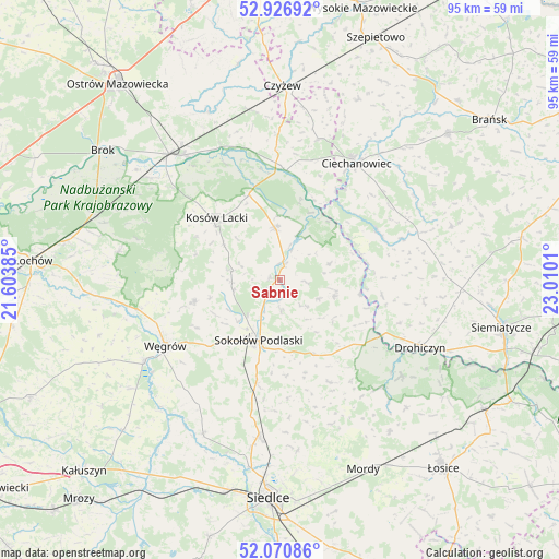
Sabnie GPS coordinates[2]
52° 30' 3.492" North, 22° 18' 25.092" East
| Map corner | latitude | longitude |
|---|---|---|
| Upper-left | 52.92692°, | 21.60385° |
| Center: | 52.50097°, | 22.30697° |
| Lower-right: | 52.07086°, | 23.0101° |
| Map W x H: | 95.2×95.2 km | = 59.2×59.2mi |
| max Lat: | 54.83135° ⇑23.6% North |
| Sabnie: | 52.50097° |
| min Lat: | ⇓76.4% South 49.21328° |
| min Long | Sabnie | max Long |
| 14.20249° | 22.30697° | 24.03723° |
| W 88.9%⇐ | ⇒11.1% E |
Elevation
Elevation of Sabnie is 131 m = 430 ft, and this is 60.4 m = 198 ft below average elevation for this country.
| Max E: |
974 m = 3196 ft | 65.6% |
| Avg. | 191.4 m = 628 ft | |
| Sabnie | 131 m = 430 ft | |
Min E: |
-3 m = -10 ft | 34.4% |
See also: Poland elevation on elevation.city.
Geographical zone
Sabnie is located in North temperate zone (between Tropic of Cancer and the Arctic Circle). Distance of this North polar circle is 1563.6 km =971.6 mi to North.| Distance of | km | miles | from Sabnie |
|---|---|---|---|
| North Pole | 4169.5 | 2590.8 | to North |
| Arctic Circle | 1563.6 | 971.6 | to North |
| Tropic Cancer | 3231.6 | 2008 | to South |
| Equator | 5837.6 | 3627.3 | to South |


Nearby cities:
15 places around Sabnie: (largest is in red/bold)
• Bielany
18.1 km =11.2 mi,  192°
192°
• Boguty-Pianki
25.1 km =15.6 mi,  16°
16°
• Ceranów
15.4 km =9.6 mi,  339°
339°
• Ciechanowiec
23.6 km =14.7 mi,  33°
33°
• Drohiczyn
26.3 km =16.3 mi,  115°
115°
• Jabłonna Lacka
9.6 km =6 mi,  106°
106°
• Kosów Lacki
15.1 km =9.4 mi,  314°
314°
• Miedzna
15.2 km =9.4 mi,  255°
255°
• Nur
18.6 km =11.6 mi,  3°
3°
• Paprotnia
24.8 km =15.4 mi,  153°
153°
• Perlejewo
18.9 km =11.7 mi,  67°
67°
• Repki
14 km =8.7 mi,  156°
156°
• Sokołów Podlaski
11.1 km =6.9 mi,  199°
199°
• Sterdyń
8.9 km =5.5 mi,  354°
354°
• Węgrów
22.7 km =14.1 mi,  240°
240°
Sources, notices
• [Note1] Compared only with cities in Poland existing in our database
• [Src1] Map data: © OpenStreetMap contributors (CC-BY-SA)
• [Src2] Other city data from geonames.org with taken over terms of usage.
• [Src3] Geographical zone / Annual Mean Temperature by Robert A. Rohde @ Wikipedia
