Jabłonna Lacka geodata
Jabłonna Lacka (Mazovia) is a populated place; located in Poland in Europe/Warsaw (GMT+2) time zone. With population of 1,500 people, there are 1837 cities with bigger population in this country. Compared to other cities in Poland, 76.1% of cities are located further ↓South; 90.9% of cities are located further ←West and 64.7% of cities have higher elevation than Jabłonna Lacka. Note1


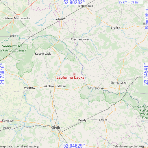
Jabłonna Lacka GPS coordinates[2]
52° 28' 35.904" North, 22° 26' 32.208" East
| Map corner | latitude | longitude |
|---|---|---|
| Upper-left | 52.90282°, | 21.73916° |
| Center: | 52.47664°, | 22.44228° |
| Lower-right: | 52.04629°, | 23.14541° |
| Map W x H: | 95.2×95.2 km | = 59.2×59.2mi |
| max Lat: | 54.83135° ⇑23.9% North |
| Jabłonna Lacka: | 52.47664° |
| min Lat: | ⇓76.1% South 49.21328° |
| min Long | Jabłonna Lacka | max Long |
| 14.20249° | 22.44228° | 24.03723° |
| W 90.9%⇐ | ⇒9.1% E |
Elevation
Elevation of Jabłonna Lacka is 134 m = 440 ft, and this is 57.4 m = 188 ft below average elevation for this country.
| Max E: |
974 m = 3196 ft | 64.7% |
| Avg. | 191.4 m = 628 ft | |
| Jabłonna Lacka | 134 m = 440 ft | |
Min E: |
-3 m = -10 ft | 35.3% |
See also: Poland elevation on elevation.city.
Geographical zone
Jabłonna Lacka is located in North temperate zone (between Tropic of Cancer and the Arctic Circle). Distance of this North polar circle is 1566.3 km =973.3 mi to North.| Distance of | km | miles | from Jabłonna Lacka |
|---|---|---|---|
| North Pole | 4172.2 | 2592.5 | to North |
| Arctic Circle | 1566.3 | 973.3 | to North |
| Tropic Cancer | 3228.9 | 2006.3 | to South |
| Equator | 5834.9 | 3625.6 | to South |


Nearby cities:
15 places around Jabłonna Lacka: (largest is in red/bold)
• Bielany
19.9 km =12.4 mi,  221°
221°
• Ceranów
22.4 km =13.9 mi,  319°
319°
• Ciechanowiec
22.7 km =14.1 mi,  9°
9°
• Drohiczyn
16.9 km =10.5 mi,  120°
120°
• Grodzisk
23.3 km =14.5 mi,  59°
59°
• Korczew
18 km =11.2 mi,  139°
139°
• Kosów Lacki
23.9 km =14.9 mi,  303°
303°
• Miedzna
23.9 km =14.9 mi,  267°
267°
• Nur
22.8 km =14.2 mi,  339°
339°
• Paprotnia
19.6 km =12.2 mi,  174°
174°
• Perlejewo
13 km =8.1 mi,  39°
39°
• Repki
10.7 km =6.6 mi,  198°
198°
• Sabnie
9.6 km =6 mi,  286°
286°
• Sokołów Podlaski
15 km =9.3 mi,  238°
238°
• Sterdyń
15.3 km =9.5 mi, 318°
Sources, notices
• [Note1] Compared only with cities in Poland existing in our database
• [Src1] Map data: © OpenStreetMap contributors (CC-BY-SA)
• [Src2] Other city data from geonames.org with taken over terms of usage.
• [Src3] Geographical zone / Annual Mean Temperature by Robert A. Rohde @ Wikipedia
