Węgrów geodata
Węgrów (Mazovia) is a seat of a second-order administrative division; located in Poland in Europe/Warsaw (GMT+2) time zone. With population of 12,512 people, there are 379 cities with bigger population in this country. Compared to other cities in Poland, 74.7% of cities are located further ↓South; 85% of cities are located further ←West and 69.8% of cities have higher elevation than Węgrów. Note1


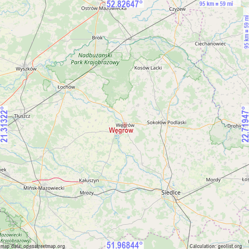
Węgrów GPS coordinates[2]
52° 23' 58.344" North, 22° 0' 58.824" East
| Map corner | latitude | longitude |
|---|---|---|
| Upper-left | 52.82647°, | 21.31322° |
| Center: | 52.39954°, | 22.01634° |
| Lower-right: | 51.96844°, | 22.71947° |
| Map W x H: | 95.4×95.4 km | = 59.3×59.3mi |
| max Lat: | 54.83135° ⇑25.3% North |
| Węgrów: | 52.39954° |
| min Lat: | ⇓74.7% South 49.21328° |
| min Long | Węgrów | max Long |
| 14.20249° | 22.01634° | 24.03723° |
| W 85%⇐ | ⇒15% E |
Elevation
Elevation of Węgrów is 121 m = 397 ft, and this is 70.4 m = 231 ft below average elevation for this country.
| Max E: |
974 m = 3196 ft | 69.8% |
| Avg. | 191.4 m = 628 ft | |
| Węgrów | 121 m = 397 ft | |
Min E: |
-3 m = -10 ft | 30.2% |
See also: Poland elevation on elevation.city.
Geographical zone
Węgrów is located in North temperate zone (between Tropic of Cancer and the Arctic Circle). Distance of this North polar circle is 1574.9 km =978.6 mi to North.| Distance of | km | miles | from Węgrów |
|---|---|---|---|
| North Pole | 4180.8 | 2597.8 | to North |
| Arctic Circle | 1574.9 | 978.6 | to North |
| Tropic Cancer | 3220.4 | 2001.1 | to South |
| Equator | 5826.3 | 3620.3 | to South |


Nearby cities:
15 places around Węgrów: (largest is in red/bold)
• Bielany
17.1 km =10.6 mi,  112°
112°
• Dobre
24.5 km =15.2 mi,  249°
249°
• Grębków
16.2 km =10.1 mi,  206°
206°
• Korytnica
11.4 km =7.1 mi,  278°
278°
• Kosów Lacki
23.5 km =14.6 mi,  22°
22°
• Kotuń
25.1 km =15.6 mi,  171°
171°
• Liw
4.3 km =2.7 mi,  230°
230°
• Miedzna
9.1 km =5.7 mi,  33°
33°
• Mokobody
16.3 km =10.1 mi,  156°
156°
• Ostrówek
24.4 km =15.2 mi,  314°
314°
• Sabnie
22.7 km =14.1 mi,  60°
60°
• Sokołów Podlaski
16.1 km =10 mi,  87°
87°
• Stoczek
17.8 km =11.1 mi,  333°
333°
• Suchożebry
22.4 km =13.9 mi,  134°
134°
• Wierzbno
14.6 km =9.1 mi, 227°
Sources, notices
• [Note1] Compared only with cities in Poland existing in our database
• [Src1] Map data: © OpenStreetMap contributors (CC-BY-SA)
• [Src2] Other city data from geonames.org with taken over terms of usage.
• [Src3] Geographical zone / Annual Mean Temperature by Robert A. Rohde @ Wikipedia
