Sokolniki geodata
Sokolniki (Subcarpathian) is a populated place; located in Poland in Europe/Warsaw (GMT+2) time zone. With population of 1,965 people, there are 1515 cities with bigger population in this country. Compared to other cities in Poland, 64.2% of cities are located further ↑North; 82.3% of cities are located further ←West and 62.1% of cities have higher elevation than Sokolniki. Note1


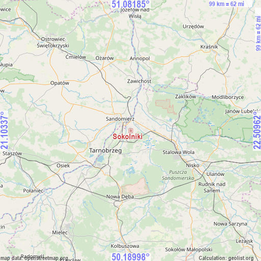
Sokolniki GPS coordinates[2]
50° 38' 16.908" North, 21° 48' 23.364" East
| Map corner | latitude | longitude |
|---|---|---|
| Upper-left | 51.08185°, | 21.10337° |
| Center: | 50.63803°, | 21.80649° |
| Lower-right: | 50.18998°, | 22.50962° |
| Map W x H: | 99.2×99.2 km | = 61.6×61.6mi |
| max Lat: | 54.83135° ⇑64.2% North |
| Sokolniki: | 50.63803° |
| min Lat: | ⇓35.8% South 49.21328° |
| min Long | Sokolniki | max Long |
| 14.20249° | 21.80649° | 24.03723° |
| W 82.3%⇐ | ⇒17.7% E |
Elevation
Elevation of Sokolniki is 142 m = 466 ft, and this is 49.4 m = 162 ft below average elevation for this country.
| Max E: |
974 m = 3196 ft | 62.1% |
| Avg. | 191.4 m = 628 ft | |
| Sokolniki | 142 m = 466 ft | |
Min E: |
-3 m = -10 ft | 37.9% |
See also: Poland elevation on elevation.city.
Geographical zone
Sokolniki is located in North temperate zone (between Tropic of Cancer and the Arctic Circle). Distance of this North polar circle is 1770.8 km =1100.3 mi to North.| Distance of | km | miles | from Sokolniki |
|---|---|---|---|
| North Pole | 4376.6 | 2719.5 | to North |
| Arctic Circle | 1770.8 | 1100.3 | to North |
| Tropic Cancer | 3024.5 | 1879.3 | to South |
| Equator | 5630.4 | 3498.6 | to South |


Nearby cities:
15 places around Sokolniki: (largest is in red/bold)
• Chwałowice
15.4 km =9.6 mi,  21°
21°
• Dwikozy
11 km =6.8 mi,  353°
353°
• Gorzyce
4 km =2.5 mi,  36°
36°
• Grębów
9.4 km =5.8 mi,  149°
149°
• Koprzywnica
16.5 km =10.3 mi,  252°
252°
• Kępie Żaleszańskie
5.3 km =3.3 mi,  87°
87°
• Obrazów
12.6 km =7.8 mi,  298°
298°
• Radomyśl
10.8 km =6.7 mi,  63°
63°
• Samborzec
11.2 km =7 mi,  274°
274°
• Sandomierz
6.4 km =4 mi,  320°
320°
• Tarnobrzeg
11.5 km =7.1 mi,  231°
231°
• Wilczyce
16 km =9.9 mi, 319°
• Zaleszany
6 km =3.7 mi,  79°
79°
• Złota
9.1 km =5.7 mi,  287°
287°
• Żabno
12.2 km =7.6 mi,  69°
69°
Sources, notices
• [Note1] Compared only with cities in Poland existing in our database
• [Src1] Map data: © OpenStreetMap contributors (CC-BY-SA)
• [Src2] Other city data from geonames.org with taken over terms of usage.
• [Src3] Geographical zone / Annual Mean Temperature by Robert A. Rohde @ Wikipedia
