Serokomla geodata
Serokomla (Lublin) is a populated place; located in Poland in Europe/Warsaw (GMT+2) time zone. With population of 1,060 people, there are 2398 cities with bigger population in this country. Compared to other cities in Poland, 60.1% of cities are located further ↓South; 89.5% of cities are located further ←West and 57.8% of cities have higher elevation than Serokomla. Note1


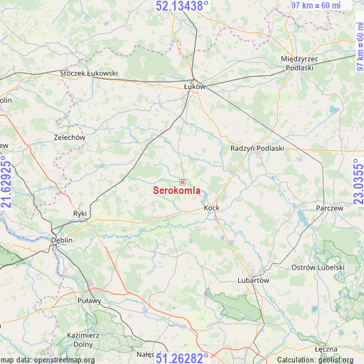
Serokomla GPS coordinates[2]
51° 42' 2.52" North, 22° 19' 56.532" East
| Map corner | latitude | longitude |
|---|---|---|
| Upper-left | 52.13438°, | 21.62925° |
| Center: | 51.7007°, | 22.33237° |
| Lower-right: | 51.26282°, | 23.0355° |
| Map W x H: | 96.9×96.9 km | = 60.2×60.2mi |
| max Lat: | 54.83135° ⇑39.9% North |
| Serokomla: | 51.7007° |
| min Lat: | ⇓60.1% South 49.21328° |
| min Long | Serokomla | max Long |
| 14.20249° | 22.33237° | 24.03723° |
| W 89.5%⇐ | ⇒10.5% E |
Elevation
Elevation of Serokomla is 151 m = 495 ft, and this is 40.4 m = 133 ft below average elevation for this country.
| Max E: |
974 m = 3196 ft | 57.8% |
| Avg. | 191.4 m = 628 ft | |
| Serokomla | 151 m = 495 ft | |
Min E: |
-3 m = -10 ft | 42.2% |
See also: Poland elevation on elevation.city.
Geographical zone
Serokomla is located in North temperate zone (between Tropic of Cancer and the Arctic Circle). Distance of this North polar circle is 1652.6 km =1026.9 mi to North.| Distance of | km | miles | from Serokomla |
|---|---|---|---|
| North Pole | 4258.5 | 2646.1 | to North |
| Arctic Circle | 1652.6 | 1026.9 | to North |
| Tropic Cancer | 3142.7 | 1952.8 | to South |
| Equator | 5748.6 | 3572 | to South |


Nearby cities:
15 places around Serokomla: (largest is in red/bold)
• Adamów
6.7 km =4.2 mi,  315°
315°
• Baranów
20.9 km =13 mi,  220°
220°
• Borki
13.2 km =8.2 mi,  79°
79°
• Bystrzyca
8.3 km =5.2 mi,  351°
351°
• Firlej
19.9 km =12.4 mi,  142°
142°
• Jeziorzany
11.6 km =7.2 mi,  199°
199°
• Kock
10.2 km =6.3 mi,  131°
131°
• Krzywda
13.9 km =8.6 mi, 319°
• Michów
19.5 km =12.1 mi,  183°
183°
• Nowodwór
17.3 km =10.7 mi,  246°
246°
• Przytoczno
10 km =6.2 mi, 204°
• Sarnów
17.5 km =10.9 mi, 353°
• Stanin
20.9 km =13 mi,  334°
334°
• Ułęż
19.7 km =12.2 mi,  232°
232°
• Wojcieszków
7.7 km =4.8 mi, 351°
Sources, notices
• [Note1] Compared only with cities in Poland existing in our database
• [Src1] Map data: © OpenStreetMap contributors (CC-BY-SA)
• [Src2] Other city data from geonames.org with taken over terms of usage.
• [Src3] Geographical zone / Annual Mean Temperature by Robert A. Rohde @ Wikipedia
