Adamów geodata
Adamów (Lublin) is a populated place; located in Poland in Europe/Warsaw (GMT+2) time zone. With population of 2,100 people, there are 1411 cities with bigger population in this country. Compared to other cities in Poland, 60.9% of cities are located further ↓South; 88.3% of cities are located further ←West and 55.6% of cities have higher elevation than Adamów. Note1


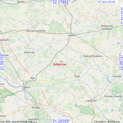
Adamów GPS coordinates[2]
51° 44' 36.06" North, 22° 15' 50.904" East
| Map corner | latitude | longitude |
|---|---|---|
| Upper-left | 52.17662°, | 21.56102° |
| Center: | 51.74335°, | 22.26414° |
| Lower-right: | 51.30589°, | 22.96727° |
| Map W x H: | 96.8×96.8 km | = 60.1×60.1mi |
| max Lat: | 54.83135° ⇑39.1% North |
| Adamów: | 51.74335° |
| min Lat: | ⇓60.9% South 49.21328° |
| min Long | Adamów | max Long |
| 14.20249° | 22.26414° | 24.03723° |
| W 88.3%⇐ | ⇒11.7% E |
Elevation
Elevation of Adamów is 157 m = 515 ft, and this is 34.4 m = 113 ft below average elevation for this country.
| Max E: |
974 m = 3196 ft | 55.6% |
| Avg. | 191.4 m = 628 ft | |
| Adamów | 157 m = 515 ft | |
Min E: |
-3 m = -10 ft | 44.4% |
See also: Poland elevation on elevation.city.
Geographical zone
Adamów is located in North temperate zone (between Tropic of Cancer and the Arctic Circle). Distance of this North polar circle is 1647.9 km =1024 mi to North.| Distance of | km | miles | from Adamów |
|---|---|---|---|
| North Pole | 4253.7 | 2643.1 | to North |
| Arctic Circle | 1647.9 | 1024 | to North |
| Tropic Cancer | 3147.4 | 1955.7 | to South |
| Equator | 5753.3 | 3574.9 | to South |


Nearby cities:
15 places around Adamów: (largest is in red/bold)
• Borki
17.9 km =11.1 mi,  97°
97°
• Bystrzyca
4.8 km =3 mi,  44°
44°
• Jeziorzany
15.7 km =9.8 mi,  176°
176°
• Kawęczyn
18.4 km =11.4 mi,  259°
259°
• Kock
16.9 km =10.5 mi,  132°
132°
• Krzywda
7.3 km =4.5 mi,  322°
322°
• Kłoczew
20.7 km =12.9 mi, 263°
• Nowodwór
16.1 km =10 mi,  223°
223°
• Przytoczno
13.8 km =8.6 mi, 177°
• Sarnów
12.9 km =8 mi,  11°
11°
• Serokomla
6.7 km =4.2 mi,  135°
135°
• Stanin
14.7 km =9.1 mi,  343°
343°
• Ułęż
20 km =12.4 mi,  212°
212°
• Wojcieszków
4.6 km =2.9 mi,  51°
51°
• Łuków
22.1 km =13.7 mi,  21°
21°
Sources, notices
• [Note1] Compared only with cities in Poland existing in our database
• [Src1] Map data: © OpenStreetMap contributors (CC-BY-SA)
• [Src2] Other city data from geonames.org with taken over terms of usage.
• [Src3] Geographical zone / Annual Mean Temperature by Robert A. Rohde @ Wikipedia
