Wojcieszków geodata
Wojcieszków (Lublin) is a populated place; located in Poland in Europe/Warsaw (GMT+2) time zone. With population of 1,100 people, there are 2307 cities with bigger population in this country. Compared to other cities in Poland, 61.5% of cities are located further ↓South; 89.1% of cities are located further ←West and 57.6% of cities have higher elevation than Wojcieszków. Note1


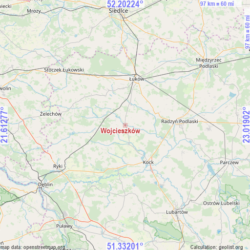
Wojcieszków GPS coordinates[2]
51° 46' 9.192" North, 22° 18' 57.204" East
| Map corner | latitude | longitude |
|---|---|---|
| Upper-left | 52.20224°, | 21.61277° |
| Center: | 51.76922°, | 22.31589° |
| Lower-right: | 51.33201°, | 23.01902° |
| Map W x H: | 96.8×96.8 km | = 60.1×60.1mi |
| max Lat: | 54.83135° ⇑38.5% North |
| Wojcieszków: | 51.76922° |
| min Lat: | ⇓61.5% South 49.21328° |
| min Long | Wojcieszków | max Long |
| 14.20249° | 22.31589° | 24.03723° |
| W 89.1%⇐ | ⇒10.9% E |
Elevation
Elevation of Wojcieszków is 152 m = 499 ft, and this is 39.4 m = 129 ft below average elevation for this country.
| Max E: |
974 m = 3196 ft | 57.6% |
| Avg. | 191.4 m = 628 ft | |
| Wojcieszków | 152 m = 499 ft | |
Min E: |
-3 m = -10 ft | 42.4% |
See also: Poland elevation on elevation.city.
Geographical zone
Wojcieszków is located in North temperate zone (between Tropic of Cancer and the Arctic Circle). Distance of this North polar circle is 1645 km =1022.2 mi to North.| Distance of | km | miles | from Wojcieszków |
|---|---|---|---|
| North Pole | 4250.9 | 2641.4 | to North |
| Arctic Circle | 1645 | 1022.2 | to North |
| Tropic Cancer | 3150.3 | 1957.5 | to South |
| Equator | 5756.2 | 3576.7 | to South |


Nearby cities:
15 places around Wojcieszków: (largest is in red/bold)
• Adamów
4.6 km =2.9 mi,  231°
231°
• Borki
15.1 km =9.4 mi,  110°
110°
• Bystrzyca
0.6 km =0.4 mi,  345°
345°
• Jeziorzany
18.7 km =11.6 mi,  188°
188°
• Kawęczyn
22.6 km =14 mi,  253°
253°
• Kock
16.9 km =10.5 mi,  148°
148°
• Krzywda
8.5 km =5.3 mi,  289°
289°
• Nowodwór
20.7 km =12.9 mi, 225°
• Przytoczno
16.9 km =10.5 mi, 190°
• Radzyń Podlaski
20.8 km =12.9 mi,  85°
85°
• Sarnów
9.8 km =6.1 mi, 354°
• Serokomla
7.7 km =4.8 mi,  171°
171°
• Stanin
13.7 km =8.5 mi,  325°
325°
• Ułęż
24.4 km =15.2 mi,  216°
216°
• Łuków
18.3 km =11.4 mi,  13°
13°
Sources, notices
• [Note1] Compared only with cities in Poland existing in our database
• [Src1] Map data: © OpenStreetMap contributors (CC-BY-SA)
• [Src2] Other city data from geonames.org with taken over terms of usage.
• [Src3] Geographical zone / Annual Mean Temperature by Robert A. Rohde @ Wikipedia
