Jeziorzany geodata
Jeziorzany (Lublin) is a seat of a third-order administrative division; located in Poland in Europe/Warsaw (GMT+2) time zone. With population of 780 people, there are 2898 cities with bigger population in this country. Compared to other cities in Poland, 58% of cities are located further ↓South; 88.4% of cities are located further ←West and 67.4% of cities have higher elevation than Jeziorzany. Note1


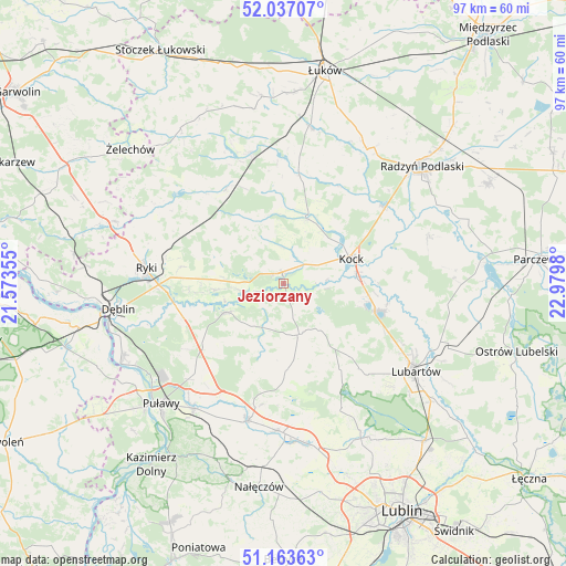
Jeziorzany GPS coordinates[2]
51° 36' 8.82" North, 22° 16' 36.012" East
| Map corner | latitude | longitude |
|---|---|---|
| Upper-left | 52.03707°, | 21.57355° |
| Center: | 51.60245°, | 22.27667° |
| Lower-right: | 51.16363°, | 22.9798° |
| Map W x H: | 97.1×97.1 km | = 60.3×60.3mi |
| max Lat: | 54.83135° ⇑42% North |
| Jeziorzany: | 51.60245° |
| min Lat: | ⇓58% South 49.21328° |
| min Long | Jeziorzany | max Long |
| 14.20249° | 22.27667° | 24.03723° |
| W 88.4%⇐ | ⇒11.6% E |
Elevation
Elevation of Jeziorzany is 127 m = 417 ft, and this is 64.4 m = 211 ft below average elevation for this country.
| Max E: |
974 m = 3196 ft | 67.4% |
| Avg. | 191.4 m = 628 ft | |
| Jeziorzany | 127 m = 417 ft | |
Min E: |
-3 m = -10 ft | 32.6% |
See also: Poland elevation on elevation.city.
Geographical zone
Jeziorzany is located in North temperate zone (between Tropic of Cancer and the Arctic Circle). Distance of this North polar circle is 1663.5 km =1033.7 mi to North.| Distance of | km | miles | from Jeziorzany |
|---|---|---|---|
| North Pole | 4269.4 | 2652.9 | to North |
| Arctic Circle | 1663.5 | 1033.7 | to North |
| Tropic Cancer | 3131.7 | 1945.9 | to South |
| Equator | 5737.7 | 3565.2 | to South |


Nearby cities:
15 places around Jeziorzany: (largest is in red/bold)
• Abramów
16.4 km =10.2 mi,  170°
170°
• Adamów
15.7 km =9.8 mi,  356°
356°
• Baranów
10.9 km =6.8 mi,  242°
242°
• Borki
21.5 km =13.4 mi,  51°
51°
• Bystrzyca
19.3 km =12 mi,  7°
7°
• Firlej
16.7 km =10.4 mi,  106°
106°
• Kamionka
19.4 km =12.1 mi,  138°
138°
• Kock
12.3 km =7.6 mi,  70°
70°
• Michów
8.9 km =5.5 mi,  163°
163°
• Nowodwór
12.7 km =7.9 mi,  288°
288°
• Przytoczno
1.9 km =1.2 mi,  349°
349°
• Serokomla
11.6 km =7.2 mi,  19°
19°
• Ułęż
11.7 km =7.3 mi,  264°
264°
• Wojcieszków
18.7 km =11.6 mi, 8°
• Żyrzyn
17.2 km =10.7 mi,  228°
228°
Sources, notices
• [Note1] Compared only with cities in Poland existing in our database
• [Src1] Map data: © OpenStreetMap contributors (CC-BY-SA)
• [Src2] Other city data from geonames.org with taken over terms of usage.
• [Src3] Geographical zone / Annual Mean Temperature by Robert A. Rohde @ Wikipedia
