Przytoczno geodata
Przytoczno (Lublin) is a populated place; located in Poland in Europe/Warsaw (GMT+2) time zone. With population of 1,100 people, there are 2307 cities with bigger population in this country. Compared to other cities in Poland, 58.4% of cities are located further ↓South; 88.4% of cities are located further ←West and 64.1% of cities have higher elevation than Przytoczno. Note1


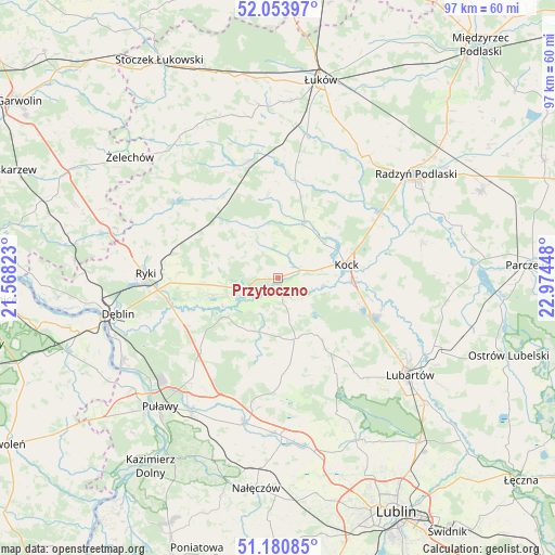
Przytoczno GPS coordinates[2]
51° 37' 10.236" North, 22° 16' 16.86" East
| Map corner | latitude | longitude |
|---|---|---|
| Upper-left | 52.05397°, | 21.56823° |
| Center: | 51.61951°, | 22.27135° |
| Lower-right: | 51.18085°, | 22.97448° |
| Map W x H: | 97.1×97.1 km | = 60.3×60.3mi |
| max Lat: | 54.83135° ⇑41.6% North |
| Przytoczno: | 51.61951° |
| min Lat: | ⇓58.4% South 49.21328° |
| min Long | Przytoczno | max Long |
| 14.20249° | 22.27135° | 24.03723° |
| W 88.4%⇐ | ⇒11.6% E |
Elevation
Elevation of Przytoczno is 136 m = 446 ft, and this is 55.4 m = 182 ft below average elevation for this country.
| Max E: |
974 m = 3196 ft | 64.1% |
| Avg. | 191.4 m = 628 ft | |
| Przytoczno | 136 m = 446 ft | |
Min E: |
-3 m = -10 ft | 35.9% |
See also: Poland elevation on elevation.city.
Geographical zone
Przytoczno is located in North temperate zone (between Tropic of Cancer and the Arctic Circle). Distance of this North polar circle is 1661.6 km =1032.5 mi to North.| Distance of | km | miles | from Przytoczno |
|---|---|---|---|
| North Pole | 4267.5 | 2651.7 | to North |
| Arctic Circle | 1661.6 | 1032.5 | to North |
| Tropic Cancer | 3133.6 | 1947.1 | to South |
| Equator | 5739.6 | 3566.4 | to South |


Nearby cities:
15 places around Przytoczno: (largest is in red/bold)
• Abramów
18.4 km =11.4 mi,  170°
170°
• Adamów
13.8 km =8.6 mi,  357°
357°
• Baranów
11.6 km =7.2 mi,  233°
233°
• Borki
20.6 km =12.8 mi,  56°
56°
• Bystrzyca
17.5 km =10.9 mi,  9°
9°
• Firlej
17.7 km =11 mi,  112°
112°
• Jeziorzany
1.9 km =1.2 mi, 169°
• Kock
12.1 km =7.5 mi,  79°
79°
• Krzywda
20.1 km =12.5 mi,  345°
345°
• Michów
10.8 km =6.7 mi,  164°
164°
• Nowodwór
11.9 km =7.4 mi,  280°
280°
• Serokomla
10 km =6.2 mi,  24°
24°
• Ułęż
11.7 km =7.3 mi,  254°
254°
• Wojcieszków
16.9 km =10.5 mi, 10°
• Żyrzyn
18.3 km =11.4 mi,  222°
222°
Sources, notices
• [Note1] Compared only with cities in Poland existing in our database
• [Src1] Map data: © OpenStreetMap contributors (CC-BY-SA)
• [Src2] Other city data from geonames.org with taken over terms of usage.
• [Src3] Geographical zone / Annual Mean Temperature by Robert A. Rohde @ Wikipedia
