Ułęż geodata
Ułęż (Lublin) is a seat of a third-order administrative division; located in Poland in Europe/Warsaw (GMT+2) time zone. With population of 1,677 people, there are 1709 cities with bigger population in this country. Compared to other cities in Poland, 57.7% of cities are located further ↓South; 86.2% of cities are located further ←West and 61.5% of cities have higher elevation than Ułęż. Note1


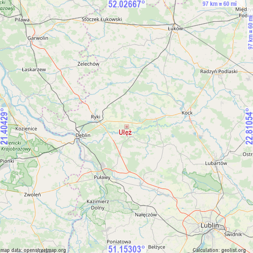
Ułęż GPS coordinates[2]
51° 35' 31.02" North, 22° 6' 26.676" East
| Map corner | latitude | longitude |
|---|---|---|
| Upper-left | 52.02667°, | 21.40429° |
| Center: | 51.59195°, | 22.10741° |
| Lower-right: | 51.15303°, | 22.81054° |
| Map W x H: | 97.1×97.1 km | = 60.3×60.3mi |
| max Lat: | 54.83135° ⇑42.3% North |
| Ułęż: | 51.59195° |
| min Lat: | ⇓57.7% South 49.21328° |
| min Long | Ułęż | max Long |
| 14.20249° | 22.10741° | 24.03723° |
| W 86.2%⇐ | ⇒13.8% E |
Elevation
Elevation of Ułęż is 143 m = 469 ft, and this is 48.4 m = 159 ft below average elevation for this country.
| Max E: |
974 m = 3196 ft | 61.5% |
| Avg. | 191.4 m = 628 ft | |
| Ułęż | 143 m = 469 ft | |
Min E: |
-3 m = -10 ft | 38.5% |
See also: Poland elevation on elevation.city.
Geographical zone
Ułęż is located in North temperate zone (between Tropic of Cancer and the Arctic Circle). Distance of this North polar circle is 1664.7 km =1034.4 mi to North.| Distance of | km | miles | from Ułęż |
|---|---|---|---|
| North Pole | 4270.6 | 2653.6 | to North |
| Arctic Circle | 1664.7 | 1034.4 | to North |
| Tropic Cancer | 3130.6 | 1945.3 | to South |
| Equator | 5736.5 | 3564.5 | to South |


Nearby cities:
15 places around Ułęż: (largest is in red/bold)
• Adamów
20 km =12.4 mi,  32°
32°
• Baranów
4.3 km =2.7 mi,  152°
152°
• Bałtów
12.7 km =7.9 mi,  207°
207°
• Bobrowniki
13 km =8.1 mi,  248°
248°
• Dęblin
18.3 km =11.4 mi,  258°
258°
• Jeziorzany
11.7 km =7.3 mi,  84°
84°
• Kawęczyn
15.3 km =9.5 mi,  331°
331°
• Kłoczew
17.4 km =10.8 mi, 325°
• Michów
16.1 km =10 mi,  117°
117°
• Moszczanka
9.8 km =6.1 mi,  275°
275°
• Nowodwór
5.2 km =3.2 mi,  355°
355°
• Przytoczno
11.7 km =7.3 mi,  74°
74°
• Ryki
12.6 km =7.8 mi,  287°
287°
• Serokomla
19.7 km =12.2 mi,  52°
52°
• Żyrzyn
10.4 km =6.5 mi,  186°
186°
Sources, notices
• [Note1] Compared only with cities in Poland existing in our database
• [Src1] Map data: © OpenStreetMap contributors (CC-BY-SA)
• [Src2] Other city data from geonames.org with taken over terms of usage.
• [Src3] Geographical zone / Annual Mean Temperature by Robert A. Rohde @ Wikipedia
