Baranów geodata
Baranów (Lublin) is a seat of a third-order administrative division; located in Poland in Europe/Warsaw (GMT+2) time zone. With population of 1,672 people, there are 1712 cities with bigger population in this country. Compared to other cities in Poland, 57.2% of cities are located further ↓South; 86.7% of cities are located further ←West and 65% of cities have higher elevation than Baranów. Note1


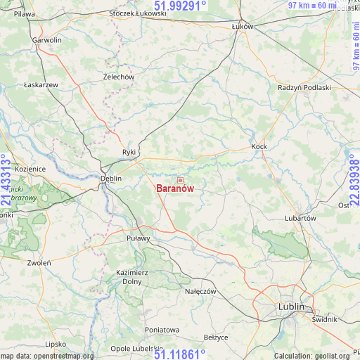
Baranów GPS coordinates[2]
51° 33' 28.296" North, 22° 8' 10.5" East
| Map corner | latitude | longitude |
|---|---|---|
| Upper-left | 51.99291°, | 21.43313° |
| Center: | 51.55786°, | 22.13625° |
| Lower-right: | 51.11861°, | 22.83938° |
| Map W x H: | 97.2×97.2 km | = 60.4×60.4mi |
| max Lat: | 54.83135° ⇑42.8% North |
| Baranów: | 51.55786° |
| min Lat: | ⇓57.2% South 49.21328° |
| min Long | Baranów | max Long |
| 14.20249° | 22.13625° | 24.03723° |
| W 86.7%⇐ | ⇒13.3% E |
Elevation
Elevation of Baranów is 133 m = 436 ft, and this is 58.4 m = 192 ft below average elevation for this country.
| Max E: |
974 m = 3196 ft | 65% |
| Avg. | 191.4 m = 628 ft | |
| Baranów | 133 m = 436 ft | |
Min E: |
-3 m = -10 ft | 35% |
See also: Poland elevation on elevation.city.
Geographical zone
Baranów is located in North temperate zone (between Tropic of Cancer and the Arctic Circle). Distance of this North polar circle is 1668.5 km =1036.8 mi to North.| Distance of | km | miles | from Baranów |
|---|---|---|---|
| North Pole | 4274.4 | 2656 | to North |
| Arctic Circle | 1668.5 | 1036.8 | to North |
| Tropic Cancer | 3126.8 | 1942.9 | to South |
| Equator | 5732.7 | 3562.1 | to South |


Nearby cities:
15 places around Baranów: (largest is in red/bold)
• Abramów
16.7 km =10.4 mi,  132°
132°
• Bałtów
10.9 km =6.8 mi,  225°
225°
• Bobrowniki
14.1 km =8.8 mi,  265°
265°
• Brzozowa Gać
18.1 km =11.2 mi,  170°
170°
• Jeziorzany
10.9 km =6.8 mi,  62°
62°
• Końskowola
17.5 km =10.9 mi,  199°
199°
• Kurów
19 km =11.8 mi, 169°
• Michów
12.8 km =8 mi,  106°
106°
• Moszczanka
12.7 km =7.9 mi,  291°
291°
• Nowodwór
9.3 km =5.8 mi,  345°
345°
• Przytoczno
11.6 km =7.2 mi,  53°
53°
• Puławy
19.5 km =12.1 mi,  216°
216°
• Ryki
16 km =9.9 mi,  298°
298°
• Ułęż
4.3 km =2.7 mi,  332°
332°
• Żyrzyn
7.2 km =4.5 mi,  205°
205°
Sources, notices
• [Note1] Compared only with cities in Poland existing in our database
• [Src1] Map data: © OpenStreetMap contributors (CC-BY-SA)
• [Src2] Other city data from geonames.org with taken over terms of usage.
• [Src3] Geographical zone / Annual Mean Temperature by Robert A. Rohde @ Wikipedia
