Nowodwór geodata
Nowodwór (Lublin) is a seat of a third-order administrative division; located in Poland in Europe/Warsaw (GMT+2) time zone. With population of 539 people, there are 3438 cities with bigger population in this country. Compared to other cities in Poland, 58.8% of cities are located further ↓South; 86.1% of cities are located further ←West and 55.6% of cities have higher elevation than Nowodwór. Note1


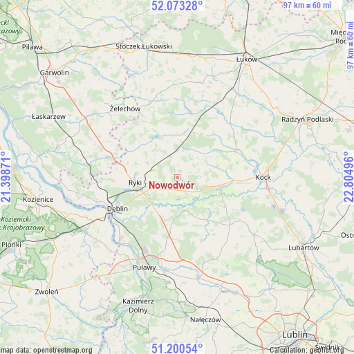
Nowodwór GPS coordinates[2]
51° 38' 20.436" North, 22° 6' 6.588" East
| Map corner | latitude | longitude |
|---|---|---|
| Upper-left | 52.07328°, | 21.39871° |
| Center: | 51.63901°, | 22.10183° |
| Lower-right: | 51.20054°, | 22.80496° |
| Map W x H: | 97×97 km | = 60.3×60.3mi |
| max Lat: | 54.83135° ⇑41.2% North |
| Nowodwór: | 51.63901° |
| min Lat: | ⇓58.8% South 49.21328° |
| min Long | Nowodwór | max Long |
| 14.20249° | 22.10183° | 24.03723° |
| W 86.1%⇐ | ⇒13.9% E |
Elevation
Elevation of Nowodwór is 157 m = 515 ft, and this is 34.4 m = 113 ft below average elevation for this country.
| Max E: |
974 m = 3196 ft | 55.6% |
| Avg. | 191.4 m = 628 ft | |
| Nowodwór | 157 m = 515 ft | |
Min E: |
-3 m = -10 ft | 44.4% |
See also: Poland elevation on elevation.city.
Geographical zone
Nowodwór is located in North temperate zone (between Tropic of Cancer and the Arctic Circle). Distance of this North polar circle is 1659.5 km =1031.2 mi to North.| Distance of | km | miles | from Nowodwór |
|---|---|---|---|
| North Pole | 4265.3 | 2650.3 | to North |
| Arctic Circle | 1659.5 | 1031.2 | to North |
| Tropic Cancer | 3135.8 | 1948.5 | to South |
| Equator | 5741.7 | 3567.7 | to South |


Nearby cities:
15 places around Nowodwór: (largest is in red/bold)
• Adamów
16.1 km =10 mi,  43°
43°
• Baranów
9.3 km =5.8 mi,  165°
165°
• Bałtów
17.4 km =10.8 mi,  198°
198°
• Bobrowniki
15.4 km =9.6 mi,  229°
229°
• Jeziorzany
12.7 km =7.9 mi,  108°
108°
• Kawęczyn
10.8 km =6.7 mi,  319°
319°
• Krzywda
18.6 km =11.6 mi,  21°
21°
• Kłoczew
13.1 km =8.1 mi,  314°
314°
• Michów
19.3 km =12 mi,  130°
130°
• Moszczanka
10.3 km =6.4 mi,  245°
245°
• Przytoczno
11.9 km =7.4 mi,  100°
100°
• Ryki
11.8 km =7.3 mi,  262°
262°
• Serokomla
17.3 km =10.7 mi,  66°
66°
• Ułęż
5.2 km =3.2 mi,  175°
175°
• Żyrzyn
15.6 km =9.7 mi, 182°
Sources, notices
• [Note1] Compared only with cities in Poland existing in our database
• [Src1] Map data: © OpenStreetMap contributors (CC-BY-SA)
• [Src2] Other city data from geonames.org with taken over terms of usage.
• [Src3] Geographical zone / Annual Mean Temperature by Robert A. Rohde @ Wikipedia
