Kock geodata
Kock (Lublin) is a seat of a third-order administrative division; located in Poland in Europe/Warsaw (GMT+2) time zone. With population of 3,484 people, there are 919 cities with bigger population in this country. Compared to other cities in Poland, 58.9% of cities are located further ↓South; 91% of cities are located further ←West and 63% of cities have higher elevation than Kock. Note1


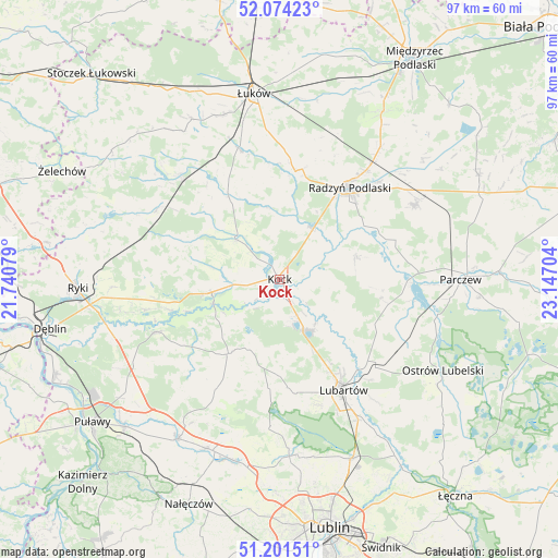
Kock GPS coordinates[2]
51° 38' 23.892" North, 22° 26' 38.076" East
| Map corner | latitude | longitude |
|---|---|---|
| Upper-left | 52.07423°, | 21.74079° |
| Center: | 51.63997°, | 22.44391° |
| Lower-right: | 51.20151°, | 23.14704° |
| Map W x H: | 97×97 km | = 60.3×60.3mi |
| max Lat: | 54.83135° ⇑41.1% North |
| Kock: | 51.63997° |
| min Lat: | ⇓58.9% South 49.21328° |
| min Long | Kock | max Long |
| 14.20249° | 22.44391° | 24.03723° |
| W 91%⇐ | ⇒9% E |
Elevation
Elevation of Kock is 139 m = 456 ft, and this is 52.4 m = 172 ft below average elevation for this country.
| Max E: |
974 m = 3196 ft | 63% |
| Avg. | 191.4 m = 628 ft | |
| Kock | 139 m = 456 ft | |
Min E: |
-3 m = -10 ft | 37% |
See also: Poland elevation on elevation.city.
Geographical zone
Kock is located in North temperate zone (between Tropic of Cancer and the Arctic Circle). Distance of this North polar circle is 1659.3 km =1031 mi to North.| Distance of | km | miles | from Kock |
|---|---|---|---|
| North Pole | 4265.2 | 2650.3 | to North |
| Arctic Circle | 1659.3 | 1031 | to North |
| Tropic Cancer | 3135.9 | 1948.6 | to South |
| Equator | 5741.8 | 3567.8 | to South |


Nearby cities:
15 places around Kock: (largest is in red/bold)
• Adamów
16.9 km =10.5 mi,  312°
312°
• Borki
10.5 km =6.5 mi,  30°
30°
• Bystrzyca
17.4 km =10.8 mi,  329°
329°
• Czemierniki
13.9 km =8.6 mi,  74°
74°
• Firlej
10.1 km =6.3 mi,  153°
153°
• Jeziorzany
12.3 km =7.6 mi,  250°
250°
• Kamionka
18.8 km =11.7 mi,  176°
176°
• Kozłówka
21.5 km =13.4 mi,  170°
170°
• Michów
15.5 km =9.6 mi,  215°
215°
• Niedźwiada
20.1 km =12.5 mi,  121°
121°
• Ostrówek
13.3 km =8.3 mi, 119°
• Przytoczno
12.1 km =7.5 mi,  259°
259°
• Radzyń Podlaski
19.9 km =12.4 mi,  36°
36°
• Serokomla
10.2 km =6.3 mi, 311°
• Wojcieszków
16.9 km =10.5 mi, 328°
Sources, notices
• [Note1] Compared only with cities in Poland existing in our database
• [Src1] Map data: © OpenStreetMap contributors (CC-BY-SA)
• [Src2] Other city data from geonames.org with taken over terms of usage.
• [Src3] Geographical zone / Annual Mean Temperature by Robert A. Rohde @ Wikipedia
