Rzeczniów geodata
Rzeczniów (Mazovia) is a seat of a third-order administrative division; located in Poland in Europe/Warsaw (GMT+2) time zone. With population of 673 people, there are 3123 cities with bigger population in this country. Compared to other cities in Poland, 51.6% of cities are located further ↑North; 78.5% of cities are located further ←West and 53.8% of cities have lower elevation than Rzeczniów. Note1


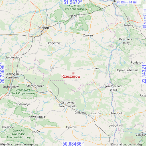
Rzeczniów GPS coordinates[2]
51° 7' 40.944" North, 21° 26' 24.288" East
| Map corner | latitude | longitude |
|---|---|---|
| Upper-left | 51.5672°, | 20.73696° |
| Center: | 51.12804°, | 21.44008° |
| Lower-right: | 50.68466°, | 22.14321° |
| Map W x H: | 98.1×98.1 km | = 61×61mi |
| max Lat: | 54.83135° ⇑51.6% North |
| Rzeczniów: | 51.12804° |
| min Lat: | ⇓48.4% South 49.21328° |
| min Long | Rzeczniów | max Long |
| 14.20249° | 21.44008° | 24.03723° |
| W 78.5%⇐ | ⇒21.5% E |
Elevation
Elevation of Rzeczniów is 182 m = 597 ft, and this is 9.4 m = 31 ft below average elevation for this country.
| Max E: |
974 m = 3196 ft | 46.2% |
| Avg. | 191.4 m = 628 ft | |
| Rzeczniów | 182 m = 597 ft | |
Min E: |
-3 m = -10 ft | 53.8% |
See also: Poland elevation on elevation.city.
Geographical zone
Rzeczniów is located in North temperate zone (between Tropic of Cancer and the Arctic Circle). Distance of this North polar circle is 1716.3 km =1066.5 mi to North.| Distance of | km | miles | from Rzeczniów |
|---|---|---|---|
| North Pole | 4322.2 | 2685.7 | to North |
| Arctic Circle | 1716.3 | 1066.5 | to North |
| Tropic Cancer | 3079 | 1913.2 | to South |
| Equator | 5684.9 | 3532.4 | to South |


Nearby cities:
15 places around Rzeczniów: (largest is in red/bold)
• Bałtów
14.2 km =8.8 mi,  149°
149°
• Brody
19.1 km =11.9 mi,  233°
233°
• Ciepielów
16.3 km =10.1 mi,  35°
35°
• Iłża
14.5 km =9 mi,  285°
285°
• Kazanów
16.6 km =10.3 mi,  6°
6°
• Kunów
21.6 km =13.4 mi,  211°
211°
• Lipsko
15 km =9.3 mi,  76°
76°
• Ostrowiec Świętokrzyski
22.4 km =13.9 mi,  189°
189°
• Pakosław
19.8 km =12.3 mi, 291°
• Prędocin
8.2 km =5.1 mi, 285°
• Sienno
5.4 km =3.4 mi, 146°
• Solec Nad Wisłą
22.7 km =14.1 mi,  87°
87°
• Tczów
22 km =13.7 mi,  1°
1°
• Wielgie
13.2 km =8.2 mi,  16°
16°
• Wymysłów
18.9 km =11.7 mi,  201°
201°
Sources, notices
• [Note1] Compared only with cities in Poland existing in our database
• [Src1] Map data: © OpenStreetMap contributors (CC-BY-SA)
• [Src2] Other city data from geonames.org with taken over terms of usage.
• [Src3] Geographical zone / Annual Mean Temperature by Robert A. Rohde @ Wikipedia
