Wielgie geodata
Wielgie (Mazovia) is a populated place; located in Poland in Europe/Warsaw (GMT+2) time zone. With population of 628 people, there are 3213 cities with bigger population in this country. Compared to other cities in Poland, 51.9% of cities are located further ↓South; 79.1% of cities are located further ←West and 53.3% of cities have higher elevation than Wielgie. Note1


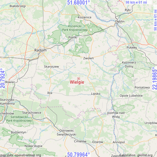
Wielgie GPS coordinates[2]
51° 14' 30.948" North, 21° 29' 43.872" East
| Map corner | latitude | longitude |
|---|---|---|
| Upper-left | 51.68001°, | 20.7924° |
| Center: | 51.24193°, | 21.49552° |
| Lower-right: | 50.79964°, | 22.19865° |
| Map W x H: | 97.9×97.9 km | = 60.8×60.8mi |
| max Lat: | 54.83135° ⇑48.1% North |
| Wielgie: | 51.24193° |
| min Lat: | ⇓51.9% South 49.21328° |
| min Long | Wielgie | max Long |
| 14.20249° | 21.49552° | 24.03723° |
| W 79.1%⇐ | ⇒20.9% E |
Elevation
Elevation of Wielgie is 163 m = 535 ft, and this is 28.4 m = 93 ft below average elevation for this country.
| Max E: |
974 m = 3196 ft | 53.3% |
| Avg. | 191.4 m = 628 ft | |
| Wielgie | 163 m = 535 ft | |
Min E: |
-3 m = -10 ft | 46.7% |
See also: Poland elevation on elevation.city.
Geographical zone
Wielgie is located in North temperate zone (between Tropic of Cancer and the Arctic Circle). Distance of this North polar circle is 1703.6 km =1058.6 mi to North.| Distance of | km | miles | from Wielgie |
|---|---|---|---|
| North Pole | 4309.5 | 2677.8 | to North |
| Arctic Circle | 1703.6 | 1058.6 | to North |
| Tropic Cancer | 3091.6 | 1921 | to South |
| Equator | 5697.6 | 3540.3 | to South |


Nearby cities:
15 places around Wielgie: (largest is in red/bold)
• Chotcza
19.6 km =12.2 mi,  90°
90°
• Ciepielów
5.6 km =3.5 mi,  82°
82°
• Gózd
17.2 km =10.7 mi,  331°
331°
• Iłża
19.9 km =12.4 mi,  243°
243°
• Kazanów
4.3 km =2.7 mi, 332°
• Lipsko
14.1 km =8.8 mi,  130°
130°
• Maków
20.4 km =12.7 mi,  304°
304°
• Przyłęk
19 km =11.8 mi,  67°
67°
• Prędocin
15.7 km =9.8 mi,  228°
228°
• Rzeczniów
13.2 km =8.2 mi,  196°
196°
• Sienno
17.2 km =10.7 mi,  182°
182°
• Skaryszew
18.6 km =11.6 mi,  294°
294°
• Solec Nad Wisłą
22.2 km =13.8 mi,  121°
121°
• Tczów
9.9 km =6.2 mi,  340°
340°
• Zwoleń
14.2 km =8.8 mi,  26°
26°
Sources, notices
• [Note1] Compared only with cities in Poland existing in our database
• [Src1] Map data: © OpenStreetMap contributors (CC-BY-SA)
• [Src2] Other city data from geonames.org with taken over terms of usage.
• [Src3] Geographical zone / Annual Mean Temperature by Robert A. Rohde @ Wikipedia
