Tczów geodata
Tczów (Mazovia) is a seat of a third-order administrative division; located in Poland in Europe/Warsaw (GMT+2) time zone. With population of 620 people, there are 3226 cities with bigger population in this country. Compared to other cities in Poland, 53.7% of cities are located further ↓South; 78.6% of cities are located further ←West and 50.8% of cities have higher elevation than Tczów. Note1


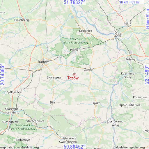
Tczów GPS coordinates[2]
51° 19' 33.6" North, 21° 26' 48.372" East
| Map corner | latitude | longitude |
|---|---|---|
| Upper-left | 51.76327°, | 20.74365° |
| Center: | 51.326°, | 21.44677° |
| Lower-right: | 50.88452°, | 22.1499° |
| Map W x H: | 97.7×97.7 km | = 60.7×60.7mi |
| max Lat: | 54.83135° ⇑46.3% North |
| Tczów: | 51.326° |
| min Lat: | ⇓53.7% South 49.21328° |
| min Long | Tczów | max Long |
| 14.20249° | 21.44677° | 24.03723° |
| W 78.6%⇐ | ⇒21.4% E |
Elevation
Elevation of Tczów is 170 m = 558 ft, and this is 21.4 m = 70 ft below average elevation for this country.
| Max E: |
974 m = 3196 ft | 50.8% |
| Avg. | 191.4 m = 628 ft | |
| Tczów | 170 m = 558 ft | |
Min E: |
-3 m = -10 ft | 49.2% |
See also: Poland elevation on elevation.city.
Geographical zone
Tczów is located in North temperate zone (between Tropic of Cancer and the Arctic Circle). Distance of this North polar circle is 1694.3 km =1052.8 mi to North.| Distance of | km | miles | from Tczów |
|---|---|---|---|
| North Pole | 4300.1 | 2672 | to North |
| Arctic Circle | 1694.3 | 1052.8 | to North |
| Tropic Cancer | 3101 | 1926.9 | to South |
| Equator | 5706.9 | 3546.1 | to South |


Nearby cities:
15 places around Tczów: (largest is in red/bold)
• Ciepielów
12.4 km =7.7 mi,  134°
134°
• Garbatka-Letnisko
20.9 km =13 mi,  33°
33°
• Gózd
7.5 km =4.7 mi,  321°
321°
• Jedlnia-Letnisko
14 km =8.7 mi,  326°
326°
• Kazanów
5.7 km =3.5 mi,  165°
165°
• Maków
13.6 km =8.5 mi,  279°
279°
• Mazowszany
21.7 km =13.5 mi,  273°
273°
• Pionki
16.7 km =10.4 mi,  0°
0°
• Policzna
19.1 km =11.9 mi,  40°
40°
• Przyłęk
21 km =13 mi,  95°
95°
• Prędocin
21.5 km =13.4 mi,  202°
202°
• Skaryszew
13.6 km =8.5 mi,  262°
262°
• Wielgie
9.9 km =6.2 mi,  160°
160°
• Zwoleń
10.3 km =6.4 mi,  71°
71°
• Łagów
21.6 km =13.4 mi,  77°
77°
Sources, notices
• [Note1] Compared only with cities in Poland existing in our database
• [Src1] Map data: © OpenStreetMap contributors (CC-BY-SA)
• [Src2] Other city data from geonames.org with taken over terms of usage.
• [Src3] Geographical zone / Annual Mean Temperature by Robert A. Rohde @ Wikipedia
