Ciepielów geodata
Ciepielów (Mazovia) is a seat of a third-order administrative division; located in Poland in Europe/Warsaw (GMT+2) time zone. With population of 770 people, there are 2920 cities with bigger population in this country. Compared to other cities in Poland, 52% of cities are located further ↓South; 79.9% of cities are located further ←West and 59.5% of cities have higher elevation than Ciepielów. Note1


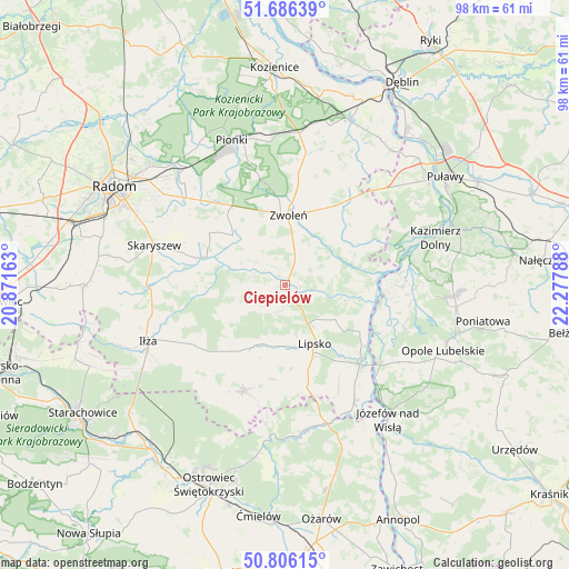
Ciepielów GPS coordinates[2]
51° 14' 54.168" North, 21° 34' 29.1" East
| Map corner | latitude | longitude |
|---|---|---|
| Upper-left | 51.68639°, | 20.87163° |
| Center: | 51.24838°, | 21.57475° |
| Lower-right: | 50.80615°, | 22.27788° |
| Map W x H: | 97.9×97.9 km | = 60.8×60.8mi |
| max Lat: | 54.83135° ⇑48% North |
| Ciepielów: | 51.24838° |
| min Lat: | ⇓52% South 49.21328° |
| min Long | Ciepielów | max Long |
| 14.20249° | 21.57475° | 24.03723° |
| W 79.9%⇐ | ⇒20.1% E |
Elevation
Elevation of Ciepielów is 148 m = 486 ft, and this is 43.4 m = 142 ft below average elevation for this country.
| Max E: |
974 m = 3196 ft | 59.5% |
| Avg. | 191.4 m = 628 ft | |
| Ciepielów | 148 m = 486 ft | |
Min E: |
-3 m = -10 ft | 40.5% |
See also: Poland elevation on elevation.city.
Geographical zone
Ciepielów is located in North temperate zone (between Tropic of Cancer and the Arctic Circle). Distance of this North polar circle is 1702.9 km =1058.1 mi to North.| Distance of | km | miles | from Ciepielów |
|---|---|---|---|
| North Pole | 4308.8 | 2677.4 | to North |
| Arctic Circle | 1702.9 | 1058.1 | to North |
| Tropic Cancer | 3092.4 | 1921.5 | to South |
| Equator | 5698.3 | 3540.8 | to South |


Nearby cities:
15 places around Ciepielów: (largest is in red/bold)
• Chotcza
14.1 km =8.8 mi,  93°
93°
• Gózd
19.8 km =12.3 mi,  316°
316°
• Kazanów
8.1 km =5 mi,  292°
292°
• Lipsko
11.2 km =7 mi,  152°
152°
• Policzna
23.3 km =14.5 mi,  8°
8°
• Przyłęk
13.7 km =8.5 mi,  60°
60°
• Prędocin
20.6 km =12.8 mi,  237°
237°
• Rzeczniów
16.3 km =10.1 mi,  215°
215°
• Sienno
19 km =11.8 mi,  199°
199°
• Solec Nad Wisłą
18.2 km =11.3 mi,  133°
133°
• Tczów
12.4 km =7.7 mi,  314°
314°
• Wielgie
5.6 km =3.5 mi,  262°
262°
• Wilków
21.1 km =13.1 mi, 85°
• Zwoleń
11.9 km =7.4 mi,  4°
4°
• Łagów
18 km =11.2 mi,  42°
42°
Sources, notices
• [Note1] Compared only with cities in Poland existing in our database
• [Src1] Map data: © OpenStreetMap contributors (CC-BY-SA)
• [Src2] Other city data from geonames.org with taken over terms of usage.
• [Src3] Geographical zone / Annual Mean Temperature by Robert A. Rohde @ Wikipedia
