Prędocin geodata
Prędocin (Mazovia) is a populated place; located in Poland in Europe/Warsaw (GMT+2) time zone. With population of 536 people, there are 3445 cities with bigger population in this country. Compared to other cities in Poland, 50.4% of cities are located further ↑North; 77.2% of cities are located further ←West and 62.2% of cities have lower elevation than Prędocin. Note1


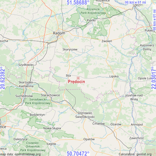
Prędocin GPS coordinates[2]
51° 8' 52.476" North, 21° 19' 37.344" East
| Map corner | latitude | longitude |
|---|---|---|
| Upper-left | 51.58688°, | 20.62392° |
| Center: | 51.14791°, | 21.32704° |
| Lower-right: | 50.70472°, | 22.03017° |
| Map W x H: | 98.1×98.1 km | = 61×61mi |
| max Lat: | 54.83135° ⇑50.4% North |
| Prędocin: | 51.14791° |
| min Lat: | ⇓49.6% South 49.21328° |
| min Long | Prędocin | max Long |
| 14.20249° | 21.32704° | 24.03723° |
| W 77.2%⇐ | ⇒22.8% E |
Elevation
Elevation of Prędocin is 206 m = 676 ft, and this is 14.6 m = 48 ft above average elevation for this country.
| Max E: |
974 m = 3196 ft | 37.8% |
| Prędocin | 206 m 676 ft | |
| Avg. | 191.4 m = 628 ft | |
Min E: |
-3 m = -10 ft | 62.2% |
See also: Poland elevation on elevation.city.
Geographical zone
Prędocin is located in North temperate zone (between Tropic of Cancer and the Arctic Circle). Distance of this North polar circle is 1714.1 km =1065.1 mi to North.| Distance of | km | miles | from Prędocin |
|---|---|---|---|
| North Pole | 4319.9 | 2684.3 | to North |
| Arctic Circle | 1714.1 | 1065.1 | to North |
| Tropic Cancer | 3081.2 | 1914.6 | to South |
| Equator | 5687.1 | 3533.8 | to South |


Nearby cities:
15 places around Prędocin: (largest is in red/bold)
• Adamów
19 km =11.8 mi,  221°
221°
• Bałtów
20.9 km =13 mi,  133°
133°
• Brody
15.6 km =9.7 mi,  208°
208°
• Ciepielów
20.6 km =12.8 mi,  57°
57°
• Iłża
6.3 km =3.9 mi,  285°
285°
• Kazanów
17.3 km =10.7 mi,  34°
34°
• Mirzec
18.9 km =11.7 mi,  265°
265°
• Mirów Stary
20.2 km =12.6 mi,  282°
282°
• Pakosław
11.6 km =7.2 mi, 294°
• Rzeczniów
8.2 km =5.1 mi,  105°
105°
• Sienno
12.8 km =8 mi,  121°
121°
• Skaryszew
18.8 km =11.7 mi,  343°
343°
• Wielgie
15.7 km =9.8 mi,  48°
48°
• Wierzbica
20.4 km =12.7 mi,  303°
303°
• Wymysłów
19.9 km =12.4 mi,  176°
176°
Sources, notices
• [Note1] Compared only with cities in Poland existing in our database
• [Src1] Map data: © OpenStreetMap contributors (CC-BY-SA)
• [Src2] Other city data from geonames.org with taken over terms of usage.
• [Src3] Geographical zone / Annual Mean Temperature by Robert A. Rohde @ Wikipedia
