Perlejewo geodata
Perlejewo (Podlasie) is a seat of a third-order administrative division; located in Poland in Europe/Warsaw (GMT+2) time zone. In our database, there are 3649 cities with bigger population. Compared to other cities in Poland, 77.4% of cities are located further ↓South; 92.4% of cities are located further ←West and 67.8% of cities have higher elevation than Perlejewo. Note1


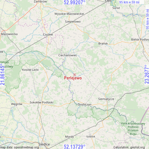
Perlejewo GPS coordinates[2]
52° 34' 0.336" North, 22° 33' 52.452" East
| Map corner | latitude | longitude |
|---|---|---|
| Upper-left | 52.99207°, | 21.86145° |
| Center: | 52.56676°, | 22.56457° |
| Lower-right: | 52.13729°, | 23.2677° |
| Map W x H: | 95×95 km | = 59×59mi |
| max Lat: | 54.83135° ⇑22.6% North |
| Perlejewo: | 52.56676° |
| min Lat: | ⇓77.4% South 49.21328° |
| min Long | Perlejewo | max Long |
| 14.20249° | 22.56457° | 24.03723° |
| W 92.4%⇐ | ⇒7.6% E |
Elevation
Elevation of Perlejewo is 126 m = 413 ft, and this is 65.4 m = 215 ft below average elevation for this country.
| Max E: |
974 m = 3196 ft | 67.8% |
| Avg. | 191.4 m = 628 ft | |
| Perlejewo | 126 m = 413 ft | |
Min E: |
-3 m = -10 ft | 32.2% |
See also: Poland elevation on elevation.city.
Geographical zone
Perlejewo is located in North temperate zone (between Tropic of Cancer and the Arctic Circle). Distance of this North polar circle is 1556.3 km =967 mi to North.| Distance of | km | miles | from Perlejewo |
|---|---|---|---|
| North Pole | 4162.2 | 2586.3 | to North |
| Arctic Circle | 1556.3 | 967 | to North |
| Tropic Cancer | 3239 | 2012.6 | to South |
| Equator | 5844.9 | 3631.9 | to South |


Nearby cities:
15 places around Perlejewo: (largest is in red/bold)
• Boguty-Pianki
19.5 km =12.1 mi,  328°
328°
• Ceranów
23.8 km =14.8 mi,  287°
287°
• Ciechanowiec
13.2 km =8.2 mi,  340°
340°
• Drohiczyn
19.6 km =12.2 mi,  161°
161°
• Dziadkowice
23.8 km =14.8 mi,  90°
90°
• Grodzisk
11.9 km =7.4 mi,  80°
80°
• Jabłonna Lacka
13 km =8.1 mi,  219°
219°
• Klukowo
23.7 km =14.7 mi,  350°
350°
• Korczew
24 km =14.9 mi,  172°
172°
• Nur
19.9 km =12.4 mi,  304°
304°
• Repki
23.3 km =14.5 mi,  210°
210°
• Rudka
20.7 km =12.9 mi,  31°
31°
• Sabnie
18.9 km =11.7 mi,  247°
247°
• Siemiatycze
25.4 km =15.8 mi,  127°
127°
• Sterdyń
18.4 km =11.4 mi,  274°
274°
Sources, notices
• [Note1] Compared only with cities in Poland existing in our database
• [Src1] Map data: © OpenStreetMap contributors (CC-BY-SA)
• [Src2] Other city data from geonames.org with taken over terms of usage.
• [Src3] Geographical zone / Annual Mean Temperature by Robert A. Rohde @ Wikipedia
