Ciechanów geodata
Ciechanów (Mazovia) is a seat of a second-order administrative division; located in Poland in Europe/Warsaw (GMT+2) time zone. With population of 46,438 people, there are 113 cities with bigger population in this country. Compared to other cities in Poland, 82.1% of cities are located further ↓South; 66.5% of cities are located further ←West and 71.1% of cities have higher elevation than Ciechanów. Note1


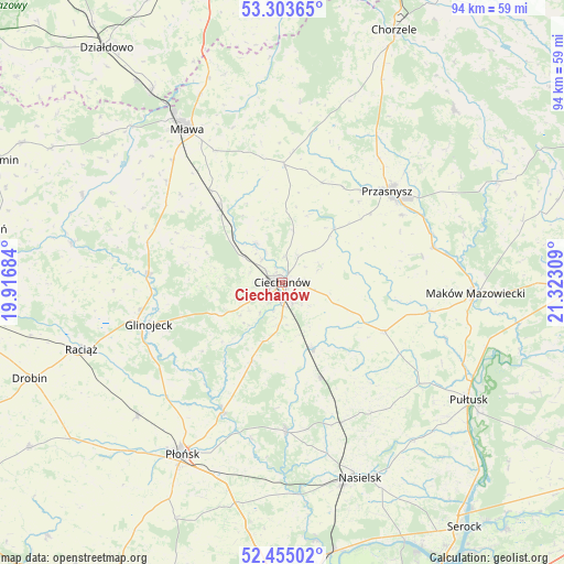
Ciechanów GPS coordinates[2]
52° 52' 53.076" North, 20° 37' 11.856" East
| Map corner | latitude | longitude |
|---|---|---|
| Upper-left | 53.30365°, | 19.91684° |
| Center: | 52.88141°, | 20.61996° |
| Lower-right: | 52.45502°, | 21.32309° |
| Map W x H: | 94.4×94.4 km | = 58.7×58.7mi |
| max Lat: | 54.83135° ⇑17.9% North |
| Ciechanów: | 52.88141° |
| min Lat: | ⇓82.1% South 49.21328° |
| min Long | Ciechanów | max Long |
| 14.20249° | 20.61996° | 24.03723° |
| W 66.5%⇐ | ⇒33.5% E |
Elevation
Elevation of Ciechanów is 119 m = 390 ft, and this is 72.4 m = 238 ft below average elevation for this country.
| Max E: |
974 m = 3196 ft | 71.1% |
| Avg. | 191.4 m = 628 ft | |
| Ciechanów | 119 m = 390 ft | |
Min E: |
-3 m = -10 ft | 28.9% |
See also: Ciechanów elevation on elevation.city.
Geographical zone
Ciechanów is located in North temperate zone (between Tropic of Cancer and the Arctic Circle). Distance of this North polar circle is 1521.3 km =945.3 mi to North.| Distance of | km | miles | from Ciechanów |
|---|---|---|---|
| North Pole | 4127.2 | 2564.5 | to North |
| Arctic Circle | 1521.3 | 945.3 | to North |
| Tropic Cancer | 3273.9 | 2034.3 | to South |
| Equator | 5879.9 | 3653.6 | to South |


Nearby cities:
15 places around Ciechanów: (largest is in red/bold)
• Czernice Borowe
18 km =11.2 mi,  21°
21°
• Glinojeck
23.1 km =14.4 mi,  252°
252°
• Gołotczyzna
11.3 km =7 mi,  155°
155°
• Gołymin-Ośrodek
18.9 km =11.7 mi,  115°
115°
• Grudusk
19.7 km =12.2 mi,  0°
0°
• Gąsocin
17.1 km =10.6 mi, 158°
• Krasne
23.8 km =14.8 mi,  78°
78°
• Ojrzeń
13.9 km =8.6 mi,  201°
201°
• Opinogóra Górna
7.1 km =4.4 mi,  67°
67°
• Przasnysz
23.2 km =14.4 mi,  48°
48°
• Regimin
8.1 km =5 mi,  326°
326°
• Sochocin
23.8 km =14.8 mi, 204°
• Sońsk
12.3 km =7.6 mi,  154°
154°
• Strzegowo
22.5 km =14 mi,  273°
273°
• Stupsk
19.9 km =12.4 mi,  321°
321°
Sources, notices
• [Note1] Compared only with cities in Poland existing in our database
• [Src1] Map data: © OpenStreetMap contributors (CC-BY-SA)
• [Src2] Other city data from geonames.org with taken over terms of usage.
• [Src3] Geographical zone / Annual Mean Temperature by Robert A. Rohde @ Wikipedia
