Glinojeck geodata
Glinojeck (Mazovia) is a seat of a third-order administrative division; located in Poland in Europe/Warsaw (GMT+2) time zone. With population of 3,117 people, there are 1011 cities with bigger population in this country. Compared to other cities in Poland, 81.1% of cities are located further ↓South; 62.4% of cities are located further ←West and 78.4% of cities have higher elevation than Glinojeck. Note1


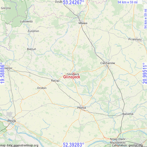
Glinojeck GPS coordinates[2]
52° 49' 11.388" North, 20° 17' 31.128" East
| Map corner | latitude | longitude |
|---|---|---|
| Upper-left | 53.24267°, | 19.58886° |
| Center: | 52.81983°, | 20.29198° |
| Lower-right: | 52.39283°, | 20.99511° |
| Map W x H: | 94.5×94.5 km | = 58.7×58.7mi |
| max Lat: | 54.83135° ⇑18.9% North |
| Glinojeck: | 52.81983° |
| min Lat: | ⇓81.1% South 49.21328° |
| min Long | Glinojeck | max Long |
| 14.20249° | 20.29198° | 24.03723° |
| W 62.4%⇐ | ⇒37.6% E |
Elevation
Elevation of Glinojeck is 103 m = 338 ft, and this is 88.4 m = 290 ft below average elevation for this country.
| Max E: |
974 m = 3196 ft | 78.4% |
| Avg. | 191.4 m = 628 ft | |
| Glinojeck | 103 m = 338 ft | |
Min E: |
-3 m = -10 ft | 21.6% |
See also: Poland elevation on elevation.city.
Geographical zone
Glinojeck is located in North temperate zone (between Tropic of Cancer and the Arctic Circle). Distance of this North polar circle is 1528.2 km =949.6 mi to North.| Distance of | km | miles | from Glinojeck |
|---|---|---|---|
| North Pole | 4134 | 2568.7 | to North |
| Arctic Circle | 1528.2 | 949.6 | to North |
| Tropic Cancer | 3267.1 | 2030.1 | to South |
| Equator | 5873 | 3649.3 | to South |


Nearby cities:
15 places around Glinojeck: (largest is in red/bold)
• Baboszewo
15.7 km =9.8 mi,  189°
189°
• Ciechanów
23.1 km =14.4 mi,  72°
72°
• Drobin
22.3 km =13.9 mi,  245°
245°
• Dzierzążnia
21.7 km =13.5 mi, 190°
• Gołotczyzna
27 km =16.8 mi,  97°
97°
• Ojrzeń
17.9 km =11.1 mi,  109°
109°
• Płońsk
22.5 km =14 mi,  165°
165°
• Raciąż
12.5 km =7.8 mi, 250°
• Radzanów
19.1 km =11.9 mi,  315°
315°
• Regimin
22.2 km =13.8 mi,  52°
52°
• Siemiątkowo
18.9 km =11.7 mi,  291°
291°
• Sochocin
19.1 km =11.9 mi,  140°
140°
• Strzegowo
8.3 km =5.2 mi,  356°
356°
• Stupsk
24.5 km =15.2 mi,  23°
23°
• Szreńsk
24.4 km =15.2 mi,  331°
331°
Sources, notices
• [Note1] Compared only with cities in Poland existing in our database
• [Src1] Map data: © OpenStreetMap contributors (CC-BY-SA)
• [Src2] Other city data from geonames.org with taken over terms of usage.
• [Src3] Geographical zone / Annual Mean Temperature by Robert A. Rohde @ Wikipedia
