Czernice Borowe geodata
Czernice Borowe (Mazovia) is a seat of a third-order administrative division; located in Poland in Europe/Warsaw (GMT+2) time zone. With population of 480 people, there are 3548 cities with bigger population in this country. Compared to other cities in Poland, 84% of cities are located further ↓South; 68% of cities are located further ←West and 55.6% of cities have higher elevation than Czernice Borowe. Note1


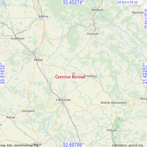
Czernice Borowe GPS coordinates[2]
53° 1' 55.092" North, 20° 43' 9.984" East
| Map corner | latitude | longitude |
|---|---|---|
| Upper-left | 53.45274°, | 20.01632° |
| Center: | 53.03197°, | 20.71944° |
| Lower-right: | 52.60706°, | 21.42257° |
| Map W x H: | 94×94 km | = 58.4×58.4mi |
| max Lat: | 54.83135° ⇑16% North |
| Czernice Borowe: | 53.03197° |
| min Lat: | ⇓84% South 49.21328° |
| min Long | Czernice Borowe | max Long |
| 14.20249° | 20.71944° | 24.03723° |
| W 68%⇐ | ⇒32% E |
Elevation
Elevation of Czernice Borowe is 157 m = 515 ft, and this is 34.4 m = 113 ft below average elevation for this country.
| Max E: |
974 m = 3196 ft | 55.6% |
| Avg. | 191.4 m = 628 ft | |
| Czernice Borowe | 157 m = 515 ft | |
Min E: |
-3 m = -10 ft | 44.4% |
See also: Poland elevation on elevation.city.
Geographical zone
Czernice Borowe is located in North temperate zone (between Tropic of Cancer and the Arctic Circle). Distance of this North polar circle is 1504.6 km =934.9 mi to North.| Distance of | km | miles | from Czernice Borowe |
|---|---|---|---|
| North Pole | 4110.5 | 2554.1 | to North |
| Arctic Circle | 1504.6 | 934.9 | to North |
| Tropic Cancer | 3290.7 | 2044.7 | to South |
| Equator | 5896.6 | 3664 | to South |


Nearby cities:
15 places around Czernice Borowe: (largest is in red/bold)
• Ciechanów
18 km =11.2 mi,  201°
201°
• Dzierzgowo
13.9 km =8.6 mi,  344°
344°
• Grudusk
7 km =4.3 mi,  294°
294°
• Jednorożec
25.3 km =15.7 mi,  61°
61°
• Krasne
20.5 km =12.7 mi,  125°
125°
• Krzynowłoga Mała
14.7 km =9.1 mi,  17°
17°
• Mława
24.1 km =15 mi, 291°
• Opinogóra Górna
14.1 km =8.8 mi,  180°
180°
• Przasnysz
10.9 km =6.8 mi,  97°
97°
• Płoniawy-Bramura
24.3 km =15.1 mi, 104°
• Regimin
15 km =9.3 mi,  227°
227°
• Stupsk
18.9 km =11.7 mi,  266°
266°
• Szydłowo
18.8 km =11.7 mi, 286°
• Wieczfnia Kościelna
24.4 km =15.2 mi,  318°
318°
• Wiśniewo
25.1 km =15.6 mi,  278°
278°
Sources, notices
• [Note1] Compared only with cities in Poland existing in our database
• [Src1] Map data: © OpenStreetMap contributors (CC-BY-SA)
• [Src2] Other city data from geonames.org with taken over terms of usage.
• [Src3] Geographical zone / Annual Mean Temperature by Robert A. Rohde @ Wikipedia
