Przasnysz geodata
Przasnysz (Mazovia) is a seat of a second-order administrative division; located in Poland in Europe/Warsaw (GMT+2) time zone. With population of 16,718 people, there are 297 cities with bigger population in this country. Compared to other cities in Poland, 83.9% of cities are located further ↓South; 70.5% of cities are located further ←West and 71.1% of cities have higher elevation than Przasnysz. Note1


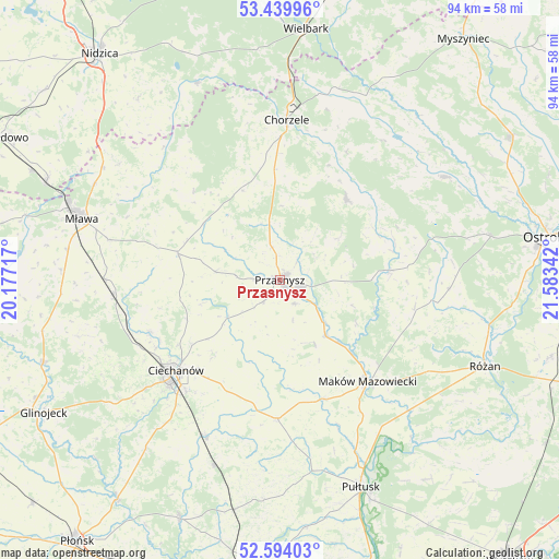
Przasnysz GPS coordinates[2]
53° 1' 8.652" North, 20° 52' 49.044" East
| Map corner | latitude | longitude |
|---|---|---|
| Upper-left | 53.43996°, | 20.17717° |
| Center: | 53.01907°, | 20.88029° |
| Lower-right: | 52.59403°, | 21.58342° |
| Map W x H: | 94.1×94.1 km | = 58.5×58.5mi |
| max Lat: | 54.83135° ⇑16.1% North |
| Przasnysz: | 53.01907° |
| min Lat: | ⇓83.9% South 49.21328° |
| min Long | Przasnysz | max Long |
| 14.20249° | 20.88029° | 24.03723° |
| W 70.5%⇐ | ⇒29.5% E |
Elevation
Elevation of Przasnysz is 119 m = 390 ft, and this is 72.4 m = 238 ft below average elevation for this country.
| Max E: |
974 m = 3196 ft | 71.1% |
| Avg. | 191.4 m = 628 ft | |
| Przasnysz | 119 m = 390 ft | |
Min E: |
-3 m = -10 ft | 28.9% |
See also: Poland elevation on elevation.city.
Geographical zone
Przasnysz is located in North temperate zone (between Tropic of Cancer and the Arctic Circle). Distance of this North polar circle is 1506 km =935.8 mi to North.| Distance of | km | miles | from Przasnysz |
|---|---|---|---|
| North Pole | 4111.9 | 2555 | to North |
| Arctic Circle | 1506 | 935.8 | to North |
| Tropic Cancer | 3289.2 | 2043.8 | to South |
| Equator | 5895.2 | 3663.1 | to South |


Nearby cities:
15 places around Przasnysz: (largest is in red/bold)
• Ciechanów
23.2 km =14.4 mi,  228°
228°
• Czernice Borowe
10.9 km =6.8 mi,  277°
277°
• Czerwonka
26.5 km =16.5 mi,  122°
122°
• Dzierzgowo
20.8 km =12.9 mi,  315°
315°
• Gołymin-Ośrodek
23.5 km =14.6 mi,  181°
181°
• Grudusk
17.6 km =10.9 mi, 284°
• Jednorożec
17.8 km =11.1 mi,  40°
40°
• Karniewo
21.5 km =13.4 mi,  160°
160°
• Krasne
12.1 km =7.5 mi,  151°
151°
• Krasnosielc
18.6 km =11.6 mi,  84°
84°
• Krzynowłoga Mała
16.7 km =10.4 mi,  337°
337°
• Maków Mazowiecki
22.6 km =14 mi,  139°
139°
• Opinogóra Górna
16.7 km =10.4 mi,  220°
220°
• Płoniawy-Bramura
13.6 km =8.5 mi,  109°
109°
• Regimin
23.5 km =14.6 mi,  248°
248°
Sources, notices
• [Note1] Compared only with cities in Poland existing in our database
• [Src1] Map data: © OpenStreetMap contributors (CC-BY-SA)
• [Src2] Other city data from geonames.org with taken over terms of usage.
• [Src3] Geographical zone / Annual Mean Temperature by Robert A. Rohde @ Wikipedia
