Opinogóra Górna geodata
Opinogóra Górna (Mazovia) is a seat of a third-order administrative division; located in Poland in Europe/Warsaw (GMT+2) time zone. With population of 630 people, there are 3202 cities with bigger population in this country. Compared to other cities in Poland, 82.5% of cities are located further ↓South; 67.9% of cities are located further ←West and 59.9% of cities have higher elevation than Opinogóra Górna. Note1


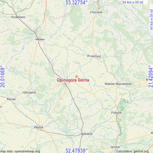
Opinogóra Górna GPS coordinates[2]
52° 54' 19.944" North, 20° 43' 4.116" East
| Map corner | latitude | longitude |
|---|---|---|
| Upper-left | 53.32754°, | 20.01469° |
| Center: | 52.90554°, | 20.71781° |
| Lower-right: | 52.47939°, | 21.42094° |
| Map W x H: | 94.3×94.3 km | = 58.6×58.6mi |
| max Lat: | 54.83135° ⇑17.5% North |
| Opinogóra Górna: | 52.90554° |
| min Lat: | ⇓82.5% South 49.21328° |
| min Long | Opinogóra Gór | max Long |
| 14.20249° | 20.71781° | 24.03723° |
| W 67.9%⇐ | ⇒32.1% E |
Elevation
Elevation of Opinogóra Górna is 147 m = 482 ft, and this is 44.4 m = 146 ft below average elevation for this country.
| Max E: |
974 m = 3196 ft | 59.9% |
| Avg. | 191.4 m = 628 ft | |
| Opinogóra Górna | 147 m = 482 ft | |
Min E: |
-3 m = -10 ft | 40.1% |
See also: Poland elevation on elevation.city.
Geographical zone
Opinogóra Górna is located in North temperate zone (between Tropic of Cancer and the Arctic Circle). Distance of this North polar circle is 1518.6 km =943.6 mi to North.| Distance of | km | miles | from Opinogóra Górna |
|---|---|---|---|
| North Pole | 4124.5 | 2562.8 | to North |
| Arctic Circle | 1518.6 | 943.6 | to North |
| Tropic Cancer | 3276.6 | 2036 | to South |
| Equator | 5882.5 | 3655.2 | to South |


Nearby cities:
15 places around Opinogóra Górna: (largest is in red/bold)
• Ciechanów
7.1 km =4.4 mi,  247°
247°
• Czernice Borowe
14.1 km =8.8 mi,  0°
0°
• Gołotczyzna
13.1 km =8.1 mi,  187°
187°
• Gołymin-Ośrodek
15.1 km =9.4 mi,  136°
136°
• Grudusk
18.1 km =11.2 mi,  339°
339°
• Gzy
23.8 km =14.8 mi, 140°
• Gąsocin
18.7 km =11.6 mi,  181°
181°
• Karniewo
19.7 km =12.2 mi,  112°
112°
• Krasne
16.9 km =10.5 mi,  83°
83°
• Ojrzeń
19.5 km =12.1 mi,  217°
217°
• Przasnysz
16.7 km =10.4 mi,  40°
40°
• Płoniawy-Bramura
25 km =15.5 mi,  71°
71°
• Regimin
11.7 km =7.3 mi,  289°
289°
• Sońsk
13.8 km =8.6 mi, 185°
• Stupsk
22.9 km =14.2 mi,  304°
304°
Sources, notices
• [Note1] Compared only with cities in Poland existing in our database
• [Src1] Map data: © OpenStreetMap contributors (CC-BY-SA)
• [Src2] Other city data from geonames.org with taken over terms of usage.
• [Src3] Geographical zone / Annual Mean Temperature by Robert A. Rohde @ Wikipedia
