Pysznica geodata
Pysznica (Subcarpathian) is a seat of a third-order administrative division; located in Poland in Europe/Warsaw (GMT+2) time zone. With population of 2,800 people, there are 1120 cities with bigger population in this country. Compared to other cities in Poland, 66% of cities are located further ↑North; 86.5% of cities are located further ←West and 56.7% of cities have higher elevation than Pysznica. Note1


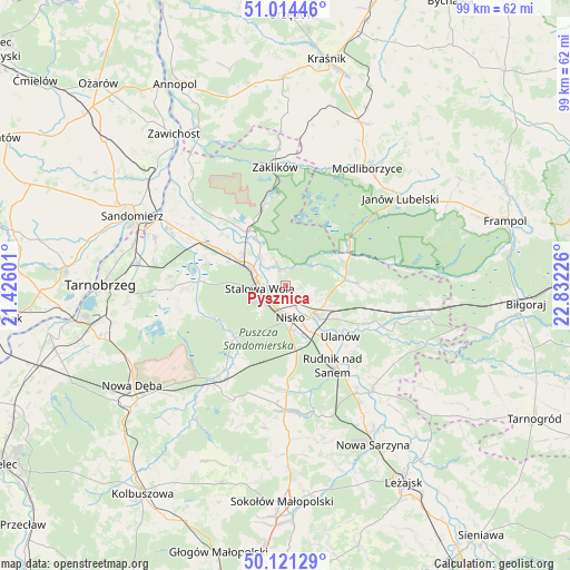
Pysznica GPS coordinates[2]
50° 34' 11.964" North, 22° 7' 44.868" East
| Map corner | latitude | longitude |
|---|---|---|
| Upper-left | 51.01446°, | 21.42601° |
| Center: | 50.56999°, | 22.12913° |
| Lower-right: | 50.12129°, | 22.83226° |
| Map W x H: | 99.3×99.3 km | = 61.7×61.7mi |
| max Lat: | 54.83135° ⇑66% North |
| Pysznica: | 50.56999° |
| min Lat: | ⇓34% South 49.21328° |
| min Long | Pysznica | max Long |
| 14.20249° | 22.12913° | 24.03723° |
| W 86.5%⇐ | ⇒13.5% E |
Elevation
Elevation of Pysznica is 154 m = 505 ft, and this is 37.4 m = 123 ft below average elevation for this country.
| Max E: |
974 m = 3196 ft | 56.7% |
| Avg. | 191.4 m = 628 ft | |
| Pysznica | 154 m = 505 ft | |
Min E: |
-3 m = -10 ft | 43.3% |
See also: Poland elevation on elevation.city.
Geographical zone
Pysznica is located in North temperate zone (between Tropic of Cancer and the Arctic Circle). Distance of this North polar circle is 1778.3 km =1105 mi to North.| Distance of | km | miles | from Pysznica |
|---|---|---|---|
| North Pole | 4384.2 | 2724.2 | to North |
| Arctic Circle | 1778.3 | 1105 | to North |
| Tropic Cancer | 3016.9 | 1874.6 | to South |
| Equator | 5622.9 | 3493.9 | to South |


Nearby cities:
15 places around Pysznica: (largest is in red/bold)
• Bieliny
18.9 km =11.7 mi,  138°
138°
• Grębów
18 km =11.2 mi,  268°
268°
• Jarocin
13.6 km =8.5 mi,  92°
92°
• Kończyce
16.1 km =10 mi,  173°
173°
• Nisko
5.6 km =3.5 mi, 172°
• Przędzel
10.5 km =6.5 mi, 142°
• Racławice
6.8 km =4.2 mi,  157°
157°
• Radomyśl
18 km =11.2 mi,  313°
313°
• Rudnik nad Sanem
16.6 km =10.3 mi,  149°
149°
• Stalowa Wola
5.5 km =3.4 mi,  284°
284°
• Ulanów
13 km =8.1 mi,  132°
132°
• Wólka Tanewska
12.1 km =7.5 mi, 129°
• Zaleszany
18.9 km =11.7 mi,  297°
297°
• Zarzecze
6.6 km =4.1 mi, 135°
• Żabno
16.3 km =10.1 mi,  316°
316°
Sources, notices
• [Note1] Compared only with cities in Poland existing in our database
• [Src1] Map data: © OpenStreetMap contributors (CC-BY-SA)
• [Src2] Other city data from geonames.org with taken over terms of usage.
• [Src3] Geographical zone / Annual Mean Temperature by Robert A. Rohde @ Wikipedia
