Stalowa Wola geodata
Stalowa Wola (Subcarpathian) is a seat of a second-order administrative division; located in Poland in Europe/Warsaw (GMT+2) time zone. With population of 66,495 people, there are 75 cities with bigger population in this country. Compared to other cities in Poland, 65.6% of cities are located further ↑North; 85.5% of cities are located further ←West and 53.7% of cities have higher elevation than Stalowa Wola. Note1
Administrative division(s):
- Level 1: Subcarpathian
- Level 2: Powiat stalowowolski
- Level 3: Stalowa Wola


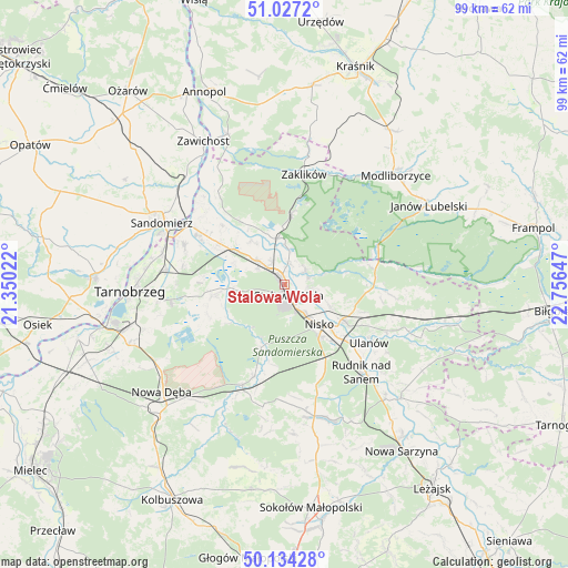
Stalowa Wola GPS coordinates[2]
50° 34' 58.296" North, 22° 3' 12.024" East
| Map corner | latitude | longitude |
|---|---|---|
| Upper-left | 51.0272°, | 21.35022° |
| Center: | 50.58286°, | 22.05334° |
| Lower-right: | 50.13428°, | 22.75647° |
| Map W x H: | 99.3×99.3 km | = 61.7×61.7mi |
| max Lat: | 54.83135° ⇑65.6% North |
| Stalowa Wola: | 50.58286° |
| min Lat: | ⇓34.4% South 49.21328° |
| min Long | Stalowa Wola | max Long |
| 14.20249° | 22.05334° | 24.03723° |
| W 85.5%⇐ | ⇒14.5% E |
Elevation
Elevation of Stalowa Wola is 162 m = 531 ft, and this is 29.4 m = 96 ft below average elevation for this country.
| Max E: |
974 m = 3196 ft | 53.7% |
| Avg. | 191.4 m = 628 ft | |
| Stalowa Wola | 162 m = 531 ft | |
Min E: |
-3 m = -10 ft | 46.3% |
See also: Stalowa Wola elevation on elevation.city.
Geographical zone
Stalowa Wola is located in North temperate zone (between Tropic of Cancer and the Arctic Circle). Distance of this North polar circle is 1776.9 km =1104.1 mi to North.| Distance of | km | miles | from Stalowa Wola |
|---|---|---|---|
| North Pole | 4382.8 | 2723.3 | to North |
| Arctic Circle | 1776.9 | 1104.1 | to North |
| Tropic Cancer | 3018.4 | 1875.5 | to South |
| Equator | 5624.3 | 3494.8 | to South |


Nearby cities:
15 places around Stalowa Wola: (largest is in red/bold)
• Gorzyce
17.7 km =11 mi,  301°
301°
• Grębów
12.8 km =8 mi,  261°
261°
• Kończyce
18.9 km =11.7 mi,  157°
157°
• Kępie Żaleszańskie
13.7 km =8.5 mi, 297°
• Nisko
9.3 km =5.8 mi,  138°
138°
• Przędzel
15.3 km =9.5 mi,  129°
129°
• Pysznica
5.5 km =3.4 mi,  104°
104°
• Racławice
11 km =6.8 mi, 134°
• Radomyśl
13.4 km =8.3 mi,  324°
324°
• Sokolniki
18.5 km =11.5 mi,  289°
289°
• Ulanów
18.1 km =11.2 mi,  124°
124°
• Wólka Tanewska
17.3 km =10.7 mi, 122°
• Zaleszany
13.6 km =8.5 mi, 302°
• Zarzecze
11.8 km =7.3 mi, 121°
• Żabno
11.9 km =7.4 mi,  330°
330°
Sources, notices
• [Note1] Compared only with cities in Poland existing in our database
• [Src1] Map data: © OpenStreetMap contributors (CC-BY-SA)
• [Src2] Other city data from geonames.org with taken over terms of usage.
• [Src3] Geographical zone / Annual Mean Temperature by Robert A. Rohde @ Wikipedia
