Tarnogóra geodata
Tarnogóra (Subcarpathian) is a populated place; located in Poland in Europe/Warsaw (GMT+2) time zone. With population of 897 people, there are 2690 cities with bigger population in this country. Compared to other cities in Poland, 70.4% of cities are located further ↑North; 89.1% of cities are located further ←West and 51.3% of cities have higher elevation than Tarnogóra. Note1


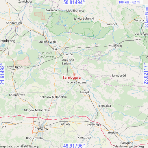
Tarnogóra GPS coordinates[2]
50° 22' 6.852" North, 22° 19' 4.944" East
| Map corner | latitude | longitude |
|---|---|---|
| Upper-left | 50.81494°, | 21.61492° |
| Center: | 50.36857°, | 22.31804° |
| Lower-right: | 49.91796°, | 23.02117° |
| Map W x H: | 99.7×99.7 km | = 62×62mi |
| max Lat: | 54.83135° ⇑70.4% North |
| Tarnogóra: | 50.36857° |
| min Lat: | ⇓29.6% South 49.21328° |
| min Long | Tarnogóra | max Long |
| 14.20249° | 22.31804° | 24.03723° |
| W 89.1%⇐ | ⇒10.9% E |
Elevation
Elevation of Tarnogóra is 169 m = 554 ft, and this is 22.4 m = 73 ft below average elevation for this country.
| Max E: |
974 m = 3196 ft | 51.3% |
| Avg. | 191.4 m = 628 ft | |
| Tarnogóra | 169 m = 554 ft | |
Min E: |
-3 m = -10 ft | 48.7% |
See also: Poland elevation on elevation.city.
Geographical zone
Tarnogóra is located in North temperate zone (between Tropic of Cancer and the Arctic Circle). Distance of this North polar circle is 1800.7 km =1118.9 mi to North.| Distance of | km | miles | from Tarnogóra |
|---|---|---|---|
| North Pole | 4406.6 | 2738.1 | to North |
| Arctic Circle | 1800.7 | 1118.9 | to North |
| Tropic Cancer | 2994.5 | 1860.7 | to South |
| Equator | 5600.5 | 3480 | to South |


Nearby cities:
15 places around Tarnogóra: (largest is in red/bold)
• Bieliny
8.3 km =5.2 mi,  353°
353°
• Bystre
5.6 km =3.5 mi,  78°
78°
• Hucisko
10.2 km =6.3 mi,  187°
187°
• Kamień
13.3 km =8.3 mi,  256°
256°
• Kończyce
13.3 km =8.3 mi,  298°
298°
• Krzeszów
4.3 km =2.7 mi,  23°
23°
• Kuryłówka
13 km =8.1 mi,  126°
126°
• Nowa Sarzyna
5.6 km =3.5 mi,  160°
160°
• Przychojec
9.8 km =6.1 mi,  142°
142°
• Rudnik nad Sanem
9.5 km =5.9 mi,  328°
328°
• Stare Miasto
11.9 km =7.4 mi, 138°
• Wola Żarczycka
9.9 km =6.2 mi,  209°
209°
• Wólka Łętowska
9.3 km =5.8 mi,  237°
237°
• Łukowa
6.1 km =3.8 mi, 142°
• Łętownia
7.7 km =4.8 mi,  230°
230°
Sources, notices
• [Note1] Compared only with cities in Poland existing in our database
• [Src1] Map data: © OpenStreetMap contributors (CC-BY-SA)
• [Src2] Other city data from geonames.org with taken over terms of usage.
• [Src3] Geographical zone / Annual Mean Temperature by Robert A. Rohde @ Wikipedia
