Bystre geodata
Bystre (Subcarpathian) is a populated place; located in Poland in Europe/Warsaw (GMT+2) time zone. With population of 585 people, there are 3323 cities with bigger population in this country. Compared to other cities in Poland, 70.1% of cities are located further ↑North; 90.1% of cities are located further ←West and 50.8% of cities have higher elevation than Bystre. Note1


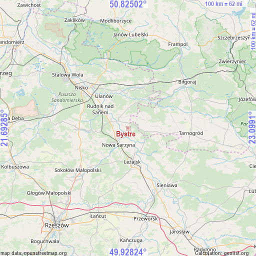
Bystre GPS coordinates[2]
50° 22' 43.5" North, 22° 23' 45.492" East
| Map corner | latitude | longitude |
|---|---|---|
| Upper-left | 50.82502°, | 21.69285° |
| Center: | 50.37875°, | 22.39597° |
| Lower-right: | 49.92824°, | 23.0991° |
| Map W x H: | 99.7×99.7 km | = 62×62mi |
| max Lat: | 54.83135° ⇑70.1% North |
| Bystre: | 50.37875° |
| min Lat: | ⇓29.9% South 49.21328° |
| min Long | Bystre | max Long |
| 14.20249° | 22.39597° | 24.03723° |
| W 90.1%⇐ | ⇒9.9% E |
Elevation
Elevation of Bystre is 170 m = 558 ft, and this is 21.4 m = 70 ft below average elevation for this country.
| Max E: |
974 m = 3196 ft | 50.8% |
| Avg. | 191.4 m = 628 ft | |
| Bystre | 170 m = 558 ft | |
Min E: |
-3 m = -10 ft | 49.2% |
See also: Poland elevation on elevation.city.
Geographical zone
Bystre is located in North temperate zone (between Tropic of Cancer and the Arctic Circle). Distance of this North polar circle is 1799.6 km =1118.2 mi to North.| Distance of | km | miles | from Bystre |
|---|---|---|---|
| North Pole | 4405.5 | 2737.4 | to North |
| Arctic Circle | 1799.6 | 1118.2 | to North |
| Tropic Cancer | 2995.7 | 1861.4 | to South |
| Equator | 5601.6 | 3480.7 | to South |


Nearby cities:
15 places around Bystre: (largest is in red/bold)
• Bieliny
9.6 km =6 mi,  317°
317°
• Harasiuki
12 km =7.5 mi,  26°
26°
• Hucisko
13.2 km =8.2 mi,  211°
211°
• Krzeszów
4.7 km =2.9 mi,  306°
306°
• Kuryłówka
10.1 km =6.3 mi,  150°
150°
• Leżajsk
13 km =8.1 mi,  172°
172°
• Nowa Sarzyna
7.4 km =4.6 mi, 209°
• Potok Górny
11.8 km =7.3 mi,  86°
86°
• Przychojec
9 km =5.6 mi,  177°
177°
• Rudnik nad Sanem
12.6 km =7.8 mi,  303°
303°
• Stare Miasto
10.3 km =6.4 mi, 166°
• Tarnogóra
5.6 km =3.5 mi,  258°
258°
• Wola Żarczycka
14.2 km =8.8 mi,  226°
226°
• Łukowa
6.2 km =3.9 mi,  197°
197°
• Łętownia
13 km =8.1 mi,  242°
242°
Sources, notices
• [Note1] Compared only with cities in Poland existing in our database
• [Src1] Map data: © OpenStreetMap contributors (CC-BY-SA)
• [Src2] Other city data from geonames.org with taken over terms of usage.
• [Src3] Geographical zone / Annual Mean Temperature by Robert A. Rohde @ Wikipedia
