Dębe Wielkie geodata
Dębe Wielkie (Mazovia) is a seat of a third-order administrative division; located in Poland in Europe/Warsaw (GMT+2) time zone. With population of 2,750 people, there are 1148 cities with bigger population in this country. Compared to other cities in Poland, 70.1% of cities are located further ↓South; 78.5% of cities are located further ←West and 67.8% of cities have higher elevation than Dębe Wielkie. Note1


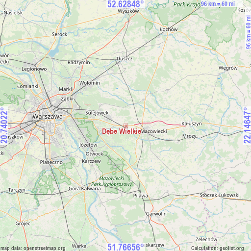
Dębe Wielkie GPS coordinates[2]
52° 11' 58.596" North, 21° 26' 36.024" East
| Map corner | latitude | longitude |
|---|---|---|
| Upper-left | 52.62848°, | 20.74022° |
| Center: | 52.19961°, | 21.44334° |
| Lower-right: | 51.76656°, | 22.14647° |
| Map W x H: | 95.8×95.8 km | = 59.5×59.5mi |
| max Lat: | 54.83135° ⇑29.9% North |
| Dębe Wielkie: | 52.19961° |
| min Lat: | ⇓70.1% South 49.21328° |
| min Long | Dębe Wielkie | max Long |
| 14.20249° | 21.44334° | 24.03723° |
| W 78.5%⇐ | ⇒21.5% E |
Elevation
Elevation of Dębe Wielkie is 126 m = 413 ft, and this is 65.4 m = 215 ft below average elevation for this country.
| Max E: |
974 m = 3196 ft | 67.8% |
| Avg. | 191.4 m = 628 ft | |
| Dębe Wielkie | 126 m = 413 ft | |
Min E: |
-3 m = -10 ft | 32.2% |
See also: Poland elevation on elevation.city.
Geographical zone
Dębe Wielkie is located in North temperate zone (between Tropic of Cancer and the Arctic Circle). Distance of this North polar circle is 1597.1 km =992.4 mi to North.| Distance of | km | miles | from Dębe Wielkie |
|---|---|---|---|
| North Pole | 4203 | 2611.6 | to North |
| Arctic Circle | 1597.1 | 992.4 | to North |
| Tropic Cancer | 3198.1 | 1987.2 | to South |
| Equator | 5804.1 | 3606.5 | to South |


Nearby cities:
15 places around Dębe Wielkie: (largest is in red/bold)
• Celestynów
15.8 km =9.8 mi,  193°
193°
• Halinów
6.8 km =4.2 mi,  298°
298°
• Jakubów
16.3 km =10.1 mi,  82°
82°
• Józefów
15.8 km =9.8 mi,  243°
243°
• Kołbiel
15.3 km =9.5 mi,  170°
170°
• Mińsk Mazowiecki
9.1 km =5.7 mi,  104°
104°
• Otwock
16.2 km =10.1 mi,  229°
229°
• Pogorzel
13.6 km =8.5 mi,  134°
134°
• Poświętne
14.5 km =9 mi,  354°
354°
• Siennica
17 km =10.6 mi,  135°
135°
• Stanisławów
12.3 km =7.6 mi,  35°
35°
• Sulejówek
13.2 km =8.2 mi, 296°
• Wawer
18.1 km =11.2 mi,  268°
268°
• Wesoła
16.1 km =10 mi,  292°
292°
• Wiązowna
10.8 km =6.7 mi,  252°
252°
Sources, notices
• [Note1] Compared only with cities in Poland existing in our database
• [Src1] Map data: © OpenStreetMap contributors (CC-BY-SA)
• [Src2] Other city data from geonames.org with taken over terms of usage.
• [Src3] Geographical zone / Annual Mean Temperature by Robert A. Rohde @ Wikipedia
