Halinów geodata
Halinów (Mazovia) is a seat of a third-order administrative division; located in Poland in Europe/Warsaw (GMT+2) time zone. With population of 3,551 people, there are 903 cities with bigger population in this country. Compared to other cities in Poland, 70.8% of cities are located further ↓South; 77.6% of cities are located further ←West and 74% of cities have higher elevation than Halinów. Note1


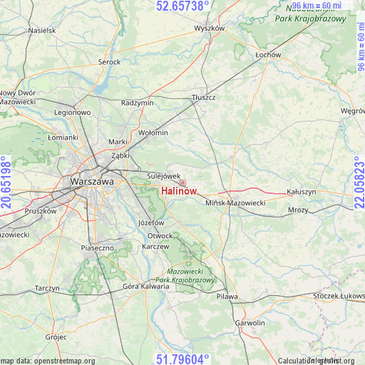
Halinów GPS coordinates[2]
52° 13' 43.68" North, 21° 21' 18.36" East
| Map corner | latitude | longitude |
|---|---|---|
| Upper-left | 52.65738°, | 20.65198° |
| Center: | 52.2288°, | 21.3551° |
| Lower-right: | 51.79604°, | 22.05823° |
| Map W x H: | 95.8×95.8 km | = 59.5×59.5mi |
| max Lat: | 54.83135° ⇑29.2% North |
| Halinów: | 52.2288° |
| min Lat: | ⇓70.8% South 49.21328° |
| min Long | Halinów | max Long |
| 14.20249° | 21.3551° | 24.03723° |
| W 77.6%⇐ | ⇒22.4% E |
Elevation
Elevation of Halinów is 113 m = 371 ft, and this is 78.4 m = 257 ft below average elevation for this country.
| Max E: |
974 m = 3196 ft | 74% |
| Avg. | 191.4 m = 628 ft | |
| Halinów | 113 m = 371 ft | |
Min E: |
-3 m = -10 ft | 26% |
See also: Poland elevation on elevation.city.
Geographical zone
Halinów is located in North temperate zone (between Tropic of Cancer and the Arctic Circle). Distance of this North polar circle is 1593.9 km =990.4 mi to North.| Distance of | km | miles | from Halinów |
|---|---|---|---|
| North Pole | 4199.8 | 2609.6 | to North |
| Arctic Circle | 1593.9 | 990.4 | to North |
| Tropic Cancer | 3201.4 | 1989.3 | to South |
| Equator | 5807.3 | 3608.5 | to South |


Nearby cities:
15 places around Halinów: (largest is in red/bold)
• Duczki
15.5 km =9.6 mi,  343°
343°
• Dębe Wielkie
6.8 km =4.2 mi,  118°
118°
• Józefów
13 km =8.1 mi,  218°
218°
• Mińsk Mazowiecki
15.8 km =9.8 mi,  110°
110°
• Nowe Lipiny
15.4 km =9.6 mi, 338°
• Otwock
15.1 km =9.4 mi,  205°
205°
• Poświętne
12.1 km =7.5 mi,  21°
21°
• Rembertów
13.5 km =8.4 mi,  285°
285°
• Stanisławów
14.8 km =9.2 mi,  62°
62°
• Sulejówek
6.4 km =4 mi, 293°
• Wawer
12.6 km =7.8 mi,  253°
253°
• Wesoła
9.4 km =5.8 mi, 287°
• Wiązowna
7.8 km =4.8 mi, 213°
• Wołomin
14.6 km =9.1 mi,  328°
328°
• Zielonka
15.7 km =9.8 mi,  302°
302°
Sources, notices
• [Note1] Compared only with cities in Poland existing in our database
• [Src1] Map data: © OpenStreetMap contributors (CC-BY-SA)
• [Src2] Other city data from geonames.org with taken over terms of usage.
• [Src3] Geographical zone / Annual Mean Temperature by Robert A. Rohde @ Wikipedia
