Siedlce geodata
Siedlce (Świętokrzyskie) is a populated place; located in Poland in Europe/Warsaw (GMT+2) time zone. With population of 610 people, there are 3248 cities with bigger population in this country. Compared to other cities in Poland, 61.6% of cities are located further ↑North; 65.1% of cities are located further ←West and 72.8% of cities have lower elevation than Siedlce. Note1


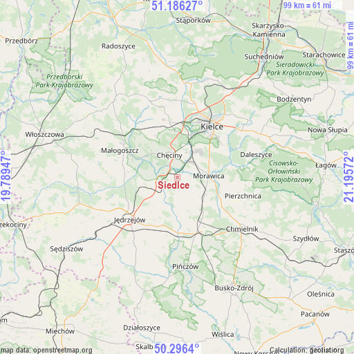
Siedlce GPS coordinates[2]
50° 44' 36.42" North, 20° 29' 33.324" East
| Map corner | latitude | longitude |
|---|---|---|
| Upper-left | 51.18627°, | 19.78947° |
| Center: | 50.74345°, | 20.49259° |
| Lower-right: | 50.2964°, | 21.19572° |
| Map W x H: | 98.9×98.9 km | = 61.5×61.5mi |
| max Lat: | 54.83135° ⇑61.6% North |
| Siedlce: | 50.74345° |
| min Lat: | ⇓38.4% South 49.21328° |
| min Long | Siedlce | max Long |
| 14.20249° | 20.49259° | 24.03723° |
| W 65.1%⇐ | ⇒34.9% E |
Elevation
Elevation of Siedlce is 239 m = 784 ft, and this is 47.6 m = 156 ft above average elevation for this country.
| Max E: |
974 m = 3196 ft | 27.2% |
| Siedlce | 239 m 784 ft | |
| Avg. | 191.4 m = 628 ft | |
Min E: |
-3 m = -10 ft | 72.8% |
See also: Poland elevation on elevation.city.
Geographical zone
Siedlce is located in North temperate zone (between Tropic of Cancer and the Arctic Circle). Distance of this North polar circle is 1759 km =1093 mi to North.| Distance of | km | miles | from Siedlce |
|---|---|---|---|
| North Pole | 4364.9 | 2712.2 | to North |
| Arctic Circle | 1759 | 1093 | to North |
| Tropic Cancer | 3036.2 | 1886.6 | to South |
| Equator | 5642.1 | 3505.8 | to South |


Nearby cities:
15 places around Siedlce: (largest is in red/bold)
• Brzeziny
6.5 km =4 mi,  60°
60°
• Chęciny
6.7 km =4.2 mi,  341°
341°
• Domaszowice
19.8 km =12.3 mi,  42°
42°
• Imielno
17.8 km =11.1 mi,  190°
190°
• Jędrzejów
17.6 km =10.9 mi,  228°
228°
• Kielce
17 km =10.6 mi,  33°
33°
• Kije
16.1 km =10 mi,  159°
159°
• Korytnica
9.6 km =6 mi,  170°
170°
• Małogoszcz
17.8 km =11.1 mi,  295°
295°
• Morawica
8.8 km =5.5 mi,  87°
87°
• Osiedle-Nowiny
8.9 km =5.5 mi,  22°
22°
• Piekoszów
15.4 km =9.6 mi,  352°
352°
• Pierzchnica
19.2 km =11.9 mi,  105°
105°
• Sobków
5.7 km =3.5 mi,  211°
211°
• Łukowa
3.9 km =2.4 mi,  122°
122°
Sources, notices
• [Note1] Compared only with cities in Poland existing in our database
• [Src1] Map data: © OpenStreetMap contributors (CC-BY-SA)
• [Src2] Other city data from geonames.org with taken over terms of usage.
• [Src3] Geographical zone / Annual Mean Temperature by Robert A. Rohde @ Wikipedia
