Maków Mazowiecki geodata
Maków Mazowiecki (Mazovia) is a seat of a second-order administrative division; located in Poland in Europe/Warsaw (GMT+2) time zone. With population of 9,978 people, there are 445 cities with bigger population in this country. Compared to other cities in Poland, 81.7% of cities are located further ↓South; 74.5% of cities are located further ←West and 80.2% of cities have higher elevation than Maków Mazowiecki. Note1


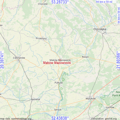
Maków Mazowiecki GPS coordinates[2]
52° 51' 53.748" North, 21° 6' 1.908" East
| Map corner | latitude | longitude |
|---|---|---|
| Upper-left | 53.28733°, | 20.39741° |
| Center: | 52.86493°, | 21.10053° |
| Lower-right: | 52.43838°, | 21.80366° |
| Map W x H: | 94.4×94.4 km | = 58.7×58.7mi |
| max Lat: | 54.83135° ⇑18.3% North |
| Maków Mazowiecki: | 52.86493° |
| min Lat: | ⇓81.7% South 49.21328° |
| min Long | Maków Mazowiec | max Long |
| 14.20249° | 21.10053° | 24.03723° |
| W 74.5%⇐ | ⇒25.5% E |
Elevation
Elevation of Maków Mazowiecki is 99 m = 325 ft, and this is 92.4 m = 303 ft below average elevation for this country.
| Max E: |
974 m = 3196 ft | 80.2% |
| Avg. | 191.4 m = 628 ft | |
| Maków Mazowiecki | 99 m = 325 ft | |
Min E: |
-3 m = -10 ft | 19.8% |
See also: Poland elevation on elevation.city.
Geographical zone
Maków Mazowiecki is located in North temperate zone (between Tropic of Cancer and the Arctic Circle). Distance of this North polar circle is 1523.1 km =946.4 mi to North.| Distance of | km | miles | from Maków Mazowiecki |
|---|---|---|---|
| North Pole | 4129 | 2565.6 | to North |
| Arctic Circle | 1523.1 | 946.4 | to North |
| Tropic Cancer | 3272.1 | 2033.2 | to South |
| Equator | 5878 | 3652.4 | to South |


Nearby cities:
15 places around Maków Mazowiecki: (largest is in red/bold)
• Czerwonka
8.3 km =5.2 mi,  68°
68°
• Gołymin-Ośrodek
16.5 km =10.3 mi,  247°
247°
• Gzy
17.4 km =10.8 mi,  217°
217°
• Karniewo
8.1 km =5 mi, 247°
• Krasne
11.1 km =6.9 mi,  306°
306°
• Krasnosielc
19.2 km =11.9 mi,  11°
11°
• Obryte
19.3 km =12 mi,  148°
148°
• Przasnysz
22.6 km =14 mi,  319°
319°
• Psary
17.8 km =11.1 mi,  159°
159°
• Pułtusk
18.1 km =11.2 mi,  183°
183°
• Płoniawy-Bramura
12.7 km =7.9 mi,  351°
351°
• Rzewnie
16.2 km =10.1 mi,  101°
101°
• Różan
19.7 km =12.2 mi,  82°
82°
• Sypniewo
20.9 km =13 mi,  41°
41°
• Szelków
8.5 km =5.3 mi,  113°
113°
Sources, notices
• [Note1] Compared only with cities in Poland existing in our database
• [Src1] Map data: © OpenStreetMap contributors (CC-BY-SA)
• [Src2] Other city data from geonames.org with taken over terms of usage.
• [Src3] Geographical zone / Annual Mean Temperature by Robert A. Rohde @ Wikipedia
