Karniewo geodata
Karniewo (Mazovia) is a seat of a third-order administrative division; located in Poland in Europe/Warsaw (GMT+2) time zone. With population of 968 people, there are 2559 cities with bigger population in this country. Compared to other cities in Poland, 81.4% of cities are located further ↓South; 72.5% of cities are located further ←West and 75% of cities have higher elevation than Karniewo. Note1


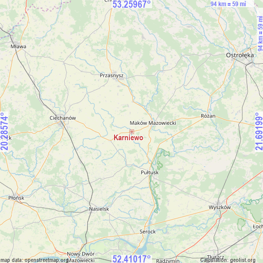
Karniewo GPS coordinates[2]
52° 50' 13.2" North, 20° 59' 19.896" East
| Map corner | latitude | longitude |
|---|---|---|
| Upper-left | 53.25967°, | 20.28574° |
| Center: | 52.837°, | 20.98886° |
| Lower-right: | 52.41017°, | 21.69199° |
| Map W x H: | 94.5×94.5 km | = 58.7×58.7mi |
| max Lat: | 54.83135° ⇑18.6% North |
| Karniewo: | 52.837° |
| min Lat: | ⇓81.4% South 49.21328° |
| min Long | Karniewo | max Long |
| 14.20249° | 20.98886° | 24.03723° |
| W 72.5%⇐ | ⇒27.5% E |
Elevation
Elevation of Karniewo is 111 m = 364 ft, and this is 80.4 m = 264 ft below average elevation for this country.
| Max E: |
974 m = 3196 ft | 75% |
| Avg. | 191.4 m = 628 ft | |
| Karniewo | 111 m = 364 ft | |
Min E: |
-3 m = -10 ft | 25% |
See also: Poland elevation on elevation.city.
Geographical zone
Karniewo is located in North temperate zone (between Tropic of Cancer and the Arctic Circle). Distance of this North polar circle is 1526.3 km =948.4 mi to North.| Distance of | km | miles | from Karniewo |
|---|---|---|---|
| North Pole | 4132.1 | 2567.6 | to North |
| Arctic Circle | 1526.3 | 948.4 | to North |
| Tropic Cancer | 3269 | 2031.3 | to South |
| Equator | 5874.9 | 3650.5 | to South |


Nearby cities:
15 places around Karniewo: (largest is in red/bold)
• Czerwonka
16.4 km =10.2 mi,  67°
67°
• Gołotczyzna
20.7 km =12.9 mi,  255°
255°
• Gołymin-Ośrodek
8.4 km =5.2 mi,  247°
247°
• Gzy
11.2 km =7 mi,  195°
195°
• Gąsocin
21.7 km =13.5 mi,  239°
239°
• Krasne
9.8 km =6.1 mi,  351°
351°
• Maków Mazowiecki
8.1 km =5 mi, 67°
• Opinogóra Górna
19.7 km =12.2 mi,  292°
292°
• Przasnysz
21.5 km =13.4 mi,  340°
340°
• Psary
19.3 km =12 mi,  135°
135°
• Pułtusk
16.2 km =10.1 mi,  157°
157°
• Płoniawy-Bramura
16.6 km =10.3 mi,  19°
19°
• Sońsk
20.4 km =12.7 mi, 252°
• Szelków
15.4 km =9.6 mi,  90°
90°
• Winnica
21.8 km =13.5 mi,  188°
188°
Sources, notices
• [Note1] Compared only with cities in Poland existing in our database
• [Src1] Map data: © OpenStreetMap contributors (CC-BY-SA)
• [Src2] Other city data from geonames.org with taken over terms of usage.
• [Src3] Geographical zone / Annual Mean Temperature by Robert A. Rohde @ Wikipedia
