Boćki geodata
Boćki (Podlasie) is a populated place; located in Poland in Europe/Warsaw (GMT+2) time zone. With population of 1,500 people, there are 1837 cities with bigger population in this country. Compared to other cities in Poland, 78.7% of cities are located further ↓South; 96.5% of cities are located further ←West and 60.6% of cities have higher elevation than Boćki. Note1


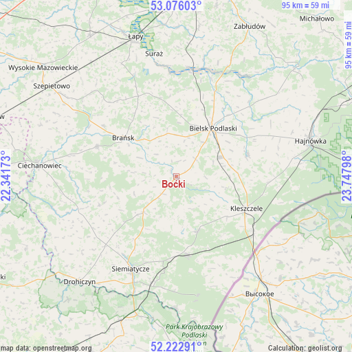
Boćki GPS coordinates[2]
52° 39' 5.58" North, 23° 2' 41.46" East
| Map corner | latitude | longitude |
|---|---|---|
| Upper-left | 53.07603°, | 22.34173° |
| Center: | 52.65155°, | 23.04485° |
| Lower-right: | 52.22291°, | 23.74798° |
| Map W x H: | 94.9×94.9 km | = 59×59mi |
| max Lat: | 54.83135° ⇑21.3% North |
| Boćki: | 52.65155° |
| min Lat: | ⇓78.7% South 49.21328° |
| min Long | Boćki | max Long |
| 14.20249° | 23.04485° | 24.03723° |
| W 96.5%⇐ | ⇒3.5% E |
Elevation
Elevation of Boćki is 145 m = 476 ft, and this is 46.4 m = 152 ft below average elevation for this country.
| Max E: |
974 m = 3196 ft | 60.6% |
| Avg. | 191.4 m = 628 ft | |
| Boćki | 145 m = 476 ft | |
Min E: |
-3 m = -10 ft | 39.4% |
See also: Poland elevation on elevation.city.
Geographical zone
Boćki is located in North temperate zone (between Tropic of Cancer and the Arctic Circle). Distance of this North polar circle is 1546.9 km =961.2 mi to North.| Distance of | km | miles | from Boćki |
|---|---|---|---|
| North Pole | 4152.8 | 2580.4 | to North |
| Arctic Circle | 1546.9 | 961.2 | to North |
| Tropic Cancer | 3248.4 | 2018.5 | to South |
| Equator | 5854.3 | 3637.7 | to South |


Nearby cities:
15 places around Boćki: (largest is in red/bold)
• Bielsk Podlaski
15.8 km =9.8 mi,  37°
37°
• Brańsk
17.4 km =10.8 mi,  306°
306°
• Czeremcha
25.5 km =15.8 mi,  126°
126°
• Czyże
28.8 km =17.9 mi,  62°
62°
• Dziadkowice
13 km =8.1 mi,  221°
221°
• Grodzisk
22 km =13.7 mi,  250°
250°
• Kleszczele
20.9 km =13 mi,  114°
114°
• Milejczyce
15.8 km =9.8 mi,  158°
158°
• Nurzec-Stacja
21.2 km =13.2 mi,  172°
172°
• Orla
20.3 km =12.6 mi,  72°
72°
• Perlejewo
33.8 km =21 mi, 253°
• Rudka
22.9 km =14.2 mi,  290°
290°
• Siemiatycze
27.8 km =17.3 mi,  206°
206°
• Suraż
33.6 km =20.9 mi,  349°
349°
• Wyszki
21.5 km =13.4 mi, 348°
Sources, notices
• [Note1] Compared only with cities in Poland existing in our database
• [Src1] Map data: © OpenStreetMap contributors (CC-BY-SA)
• [Src2] Other city data from geonames.org with taken over terms of usage.
• [Src3] Geographical zone / Annual Mean Temperature by Robert A. Rohde @ Wikipedia
