Czeremcha geodata
Czeremcha (Podlasie) is a seat of a third-order administrative division; located in Poland in Europe/Warsaw (GMT+2) time zone. With population of 2,640 people, there are 1192 cities with bigger population in this country. Compared to other cities in Poland, 76.8% of cities are located further ↓South; 98.1% of cities are located further ←West and 51.5% of cities have lower elevation than Czeremcha. Note1


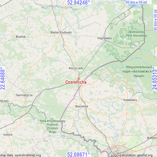
Czeremcha GPS coordinates[2]
52° 31' 0.012" North, 23° 21' 0" East
| Map corner | latitude | longitude |
|---|---|---|
| Upper-left | 52.94246°, | 22.64688° |
| Center: | 52.51667°, | 23.35° |
| Lower-right: | 52.08671°, | 24.05313° |
| Map W x H: | 95.2×95.1 km | = 59.2×59.1mi |
| max Lat: | 54.83135° ⇑23.2% North |
| Czeremcha: | 52.51667° |
| min Lat: | ⇓76.8% South 49.21328° |
| min Long | Czeremcha | max Long |
| 14.20249° | 23.35° | 24.03723° |
| W 98.1%⇐ | ⇒1.9% E |
Elevation
Elevation of Czeremcha is 176 m = 577 ft, and this is 15.4 m = 51 ft below average elevation for this country.
| Max E: |
974 m = 3196 ft | 48.5% |
| Avg. | 191.4 m = 628 ft | |
| Czeremcha | 176 m = 577 ft | |
Min E: |
-3 m = -10 ft | 51.5% |
See also: Poland elevation on elevation.city.
Geographical zone
Czeremcha is located in North temperate zone (between Tropic of Cancer and the Arctic Circle). Distance of this North polar circle is 1561.9 km =970.5 mi to North.| Distance of | km | miles | from Czeremcha |
|---|---|---|---|
| North Pole | 4167.8 | 2589.8 | to North |
| Arctic Circle | 1561.9 | 970.5 | to North |
| Tropic Cancer | 3233.4 | 2009.1 | to South |
| Equator | 5839.3 | 3628.4 | to South |


Nearby cities:
15 places around Czeremcha: (largest is in red/bold)
• Białowieża
40.4 km =25.1 mi,  59°
59°
• Bielsk Podlaski
29.7 km =18.5 mi,  338°
338°
• Boćki
25.5 km =15.8 mi,  306°
306°
• Czyże
28.7 km =17.8 mi,  9°
9°
• Dziadkowice
29.8 km =18.5 mi,  280°
280°
• Hajnówka
29.6 km =18.4 mi,  31°
31°
• Janów Podlaski
37.1 km =23.1 mi,  194°
194°
• Kleszczele
6.5 km =4 mi,  345°
345°
• Konstantynów
38.8 km =24.1 mi,  207°
207°
• Mielnik
29.2 km =18.1 mi,  225°
225°
• Milejczyce
14.7 km =9.1 mi,  271°
271°
• Nurzec-Stacja
18.9 km =11.7 mi,  251°
251°
• Orla
21 km =13 mi,  356°
356°
• Sarnaki
38.4 km =23.9 mi, 234°
• Siemiatycze
34.5 km =21.4 mi, 253°
Sources, notices
• [Note1] Compared only with cities in Poland existing in our database
• [Src1] Map data: © OpenStreetMap contributors (CC-BY-SA)
• [Src2] Other city data from geonames.org with taken over terms of usage.
• [Src3] Geographical zone / Annual Mean Temperature by Robert A. Rohde @ Wikipedia
